
Topografische Karte Tenczyn
Interaktive Karte
Klicken Sie auf die Karte, um die Höhe anzuzeigen.
Über diese Karte
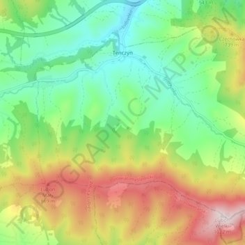
Name: Topografische Karte Tenczyn, Höhe, Relief.
Durchschnittliche Höhe: 620 m
Minimale Höhe: 381 m
Maximale Höhe: 1.008 m
Andere topografische Karten
Klicken Sie auf eine Karte, um ihre Topografie, ihre Höhe und ihr Relief anzuzeigen.
Harbutowice
Poland > Lesser Poland Voivodeship > Myślenice County
Harbutowice, gmina Sułkowice, Myślenice County, Lesser Poland Voivodeship, Poland
Durchschnittliche Höhe: 483 m
Pcim
Poland > Lesser Poland Voivodeship > Myślenice County
Pcim, gmina Pcim, Myślenice County, Lesser Poland Voivodeship, 32-432, Poland
Durchschnittliche Höhe: 483 m
Myślenice
Poland > Lesser Poland Voivodeship > Myślenice County
Myślenice, gmina Myślenice, Myślenice County, Lesser Poland Voivodeship, 32-400, Poland
Durchschnittliche Höhe: 384 m
Myślenice
Poland > Lesser Poland Voivodeship > Myślenice County > Myślenice > Myślenice
Myślenice, gmina Myślenice, Myślenice County, Lesser Poland Voivodeship, 32-400, Poland
Durchschnittliche Höhe: 374 m