
Topografische Karte Laramie
Interaktive Karte
Klicken Sie auf die Karte, um die Höhe anzuzeigen.
Über diese Karte
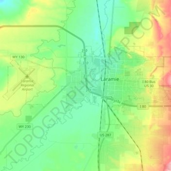
Name: Topografische Karte Laramie, Höhe, Relief.
Ort: Laramie, Albany County, Wyoming, United States (41.27742 -105.69729 41.33581 -105.52819)
Durchschnittliche Höhe: 2.219 m
Minimale Höhe: 2.166 m
Maximale Höhe: 2.462 m
Laramie (/ˈlærəmi/) is a city in and the county seat of Albany County, Wyoming, United States, known for its high elevation at 7,200 feet (2,200 m), railroad history, and as the higher-education center for the state of Wyoming. The population was estimated 31,407 in 2020, making it the 4th most populous city in Wyoming. Located on the Laramie River in southeastern Wyoming, the city is west of Cheyenne and 25 miles (40 km) north of the Colorado state line, at the junction of Interstate 80 and U.S. Route 287.
Andere topografische Karten
Klicken Sie auf eine Karte, um ihre Topografie, ihre Höhe und ihr Relief anzuzeigen.
Chalk Bluff
United States > Wyoming > Albany County
Chalk Bluff, Albany County, Wyoming, United States
Durchschnittliche Höhe: 2.153 m
Laramie
United States > Wyoming > Albany County > Laramie
Laramie, Albany County, Wyoming, 82070, United States
Durchschnittliche Höhe: 2.299 m