
Topografische Karte Hopland
Interaktive Karte
Klicken Sie auf die Karte, um die Höhe anzuzeigen.
Hopland
Hopland (formerly Sanel) is a census-designated place in Mendocino County, California, United States. It is located on the west bank of the Russian River 13 miles (21 km) south-southeast of Ukiah, in the Sanel Valley, at an elevation of 502 feet (153 m). The population was 661 at the 2020 census, down from 756 at the 2010 census.
Über diese Karte
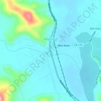
Name: Topografische Karte Hopland, Höhe, Relief.
Ort: Hopland, Mendocino County, California, United States (38.96334 -123.12672 38.97641 -123.11028)
Durchschnittliche Höhe: 165 m
Minimale Höhe: 139 m
Maximale Höhe: 314 m