
Topografische Karte Mound House
Interaktive Karte
Klicken Sie auf die Karte, um die Höhe anzuzeigen.
Über diese Karte
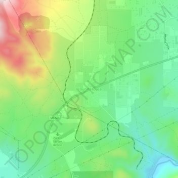
Name: Topografische Karte Mound House, Höhe, Relief.
Ort: Mound House, Lyon County, Nevada, United States (39.19224 -119.69581 39.23224 -119.65581)
Durchschnittliche Höhe: 1.521 m
Minimale Höhe: 1.359 m
Maximale Höhe: 1.810 m
Mound House is a small unincorporated community in Lyon County, Nevada on U.S. Route 50 that is situated between Nevada's capital, Carson City, and Dayton. Its elevation is 4,974 feet (1,516 m). It is in Lyon County, one of eight Nevada counties that allow for legalized prostitution, and is home to four brothels.
Andere topografische Karten
Klicken Sie auf eine Karte, um ihre Topografie, ihre Höhe und ihr Relief anzuzeigen.
Fernley
United States > Nevada > Lyon County
Fernley, Lyon County, Nevada, United States
Durchschnittliche Höhe: 1.447 m
Yerington
United States > Nevada > Lyon County
Yerington, Lyon County, Nevada, 89447, United States
Durchschnittliche Höhe: 1.358 m
Churchill Butte
United States > Nevada > Lyon County
Churchill Butte, Lyon County, Nevada, 89429, United States
Durchschnittliche Höhe: 1.645 m
Carson Rapids City
United States > Nevada > Lyon County > Dayton
Carson Rapids City, Dayton, Lyon County, Nevada, United States
Durchschnittliche Höhe: 1.394 m
Dayton
United States > Nevada > Lyon County
Dayton, Lyon County, Nevada, 89403, United States
Durchschnittliche Höhe: 1.530 m
Wellington
United States > Nevada > Lyon County
Wellington, Lyon County, Nevada, 89444, United States
Durchschnittliche Höhe: 1.523 m
Silver Springs
United States > Nevada > Lyon County
Silver Springs, Lyon County, Nevada, 89429, United States
Durchschnittliche Höhe: 1.366 m