
Topografische Karte Neuvy-sur-Barangeon
Interaktive Karte
Klicken Sie auf die Karte, um die Höhe anzuzeigen.
Über diese Karte
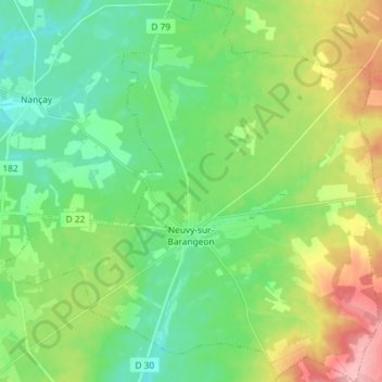
Name: Topografische Karte Neuvy-sur-Barangeon, Höhe, Relief.
Durchschnittliche Höhe: 161 m
Minimale Höhe: 121 m
Maximale Höhe: 243 m
Andere topografische Karten
Klicken Sie auf eine Karte, um ihre Topografie, ihre Höhe und ihr Relief anzuzeigen.
Ivry
France > Centre-Val de Loire > Cher > Vasselay
Ivry, Vasselay, Bourges, Cher, Centre-Val de Loire, Metropolitan France, 18110, France
Durchschnittliche Höhe: 159 m
Le Goyer
France > Centre-Val de Loire > Cher > Vierzon
Le Goyer, Vierzon, Cher, Centre-Val de Loire, Metropolitan France, 18100, France
Durchschnittliche Höhe: 135 m
Blet
France > Centre-Val de Loire > Cher
Blet, Saint-Amand-Montrond, Cher, Centre-Val de Loire, Metropolitan France, 18350, France
Durchschnittliche Höhe: 204 m
Flavigny
France > Centre-Val de Loire > Cher
Flavigny, Saint-Amand-Montrond, Cher, Centre-Val de Loire, Metropolitan France, 18350, France
Durchschnittliche Höhe: 204 m
Quincy
France > Centre-Val de Loire > Cher
Quincy, Vierzon, Cher, Centre-Val de Loire, Metropolitan France, 18120, France
Durchschnittliche Höhe: 123 m
Diane, 18370
France > Centre-Val de Loire > Cher > Préveranges
Diane, 18370, Préveranges, Saint-Amand-Montrond, Cher, Centre-Val de Loire, Metropolitan France, 18370, France
Durchschnittliche Höhe: 367 m
Raymond
France > Centre-Val de Loire > Cher
Raymond, Saint-Amand-Montrond, Cher, Centre-Val de Loire, Metropolitan France, 18130, France
Durchschnittliche Höhe: 187 m
Bourges
France > Centre-Val de Loire > Cher
Bourges, Cher, Centre-Val de Loire, Metropolitan France, 18000, France
Durchschnittliche Höhe: 146 m