
Topografische Karte Monviso
Interaktive Karte
Klicken Sie auf die Karte, um die Höhe anzuzeigen.
Über diese Karte
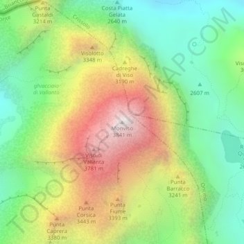
Name: Topografische Karte Monviso, Höhe, Relief.
Ort: Monviso, Pontechianale, Cuneo, Piedmont, Italy (44.66739 7.08994 44.66749 7.09004)
Durchschnittliche Höhe: 2.985 m
Minimale Höhe: 2.385 m
Maximale Höhe: 3.831 m
Monte Viso is the location of a neolithic jadeite quarry, at an elevation of 2000 to 2400 metres. Its productivity peaked around 5000 BC. The jadeite was used to make cult axes, which are found all over western Europe. One such ceremonial axe head was found as far away as a small hill called Tristia in Western Ireland and is on display in the National Museum of Ireland – Archaeology, Dublin.
Andere topografische Karten
Klicken Sie auf eine Karte, um ihre Topografie, ihre Höhe und ihr Relief anzuzeigen.
Col Agnel / Colle dell'Agnello
Italy > Piedmont > Cuneo > Pontechianale
Col Agnel / Colle dell'Agnello, Pontechianale, Cuneo, Piedmont, Italy
Durchschnittliche Höhe: 2.700 m