
Topografische Karte Ketchikan
Interaktive Karte
Klicken Sie auf die Karte, um die Höhe anzuzeigen.
Über diese Karte
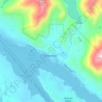
Name: Topografische Karte Ketchikan, Höhe, Relief.
Ort: Ketchikan, Ketchikan Gateway, Alaska, 99901, United States (55.32653 -131.70734 55.36437 -131.61494)
Durchschnittliche Höhe: 149 m
Minimale Höhe: -2 m
Maximale Höhe: 848 m
Due to its steep and forested terrain, Ketchikan is long and narrow with much of the built-up area being located along, or no more than a few city blocks from, the waterfront. Elevations of inhabited areas range from just above sea level to about 300 feet (91 m). Deer Mountain, a 3,001-foot (915 m) peak, rises immediately east of the city's downtown area.
Andere topografische Karten
Klicken Sie auf eine Karte, um ihre Topografie, ihre Höhe und ihr Relief anzuzeigen.
Juno Mountain
United States > Alaska > Ketchikan Gateway
Juno Mountain, Ketchikan Gateway, Alaska, 99901, United States
Durchschnittliche Höhe: 438 m
Mud Bay
United States > Alaska > Ketchikan Gateway
Mud Bay, Ketchikan Gateway, Alaska, 99928, United States
Durchschnittliche Höhe: 115 m
Marten River
United States > Alaska > Ketchikan Gateway
Marten River, Ketchikan Gateway, Alaska, United States
Durchschnittliche Höhe: 207 m
Whitman Lake
United States > Alaska > Ketchikan Gateway
Whitman Lake, Ketchikan Gateway, Alaska, United States
Durchschnittliche Höhe: 313 m
Herring Cove
United States > Alaska > Ketchikan Gateway
Herring Cove, Ketchikan Gateway, Alaska, United States
Durchschnittliche Höhe: 157 m