
Topografische Karte Ashford
Interaktive Karte
Klicken Sie auf die Karte, um die Höhe anzuzeigen.
Über diese Karte
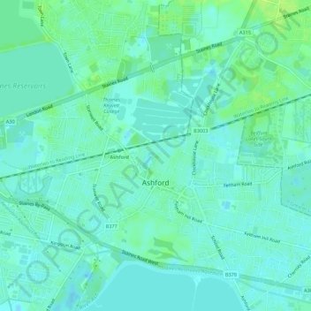
Name: Topografische Karte Ashford, Höhe, Relief.
Durchschnittliche Höhe: 16 m
Minimale Höhe: 11 m
Maximale Höhe: 23 m
Andere topografische Karten
Klicken Sie auf eine Karte, um ihre Topografie, ihre Höhe und ihr Relief anzuzeigen.
Charlton
United Kingdom > England > Surrey > Borough of Spelthorne
Charlton, Borough of Spelthorne, Surrey, England, TW17 0ST, United Kingdom
Durchschnittliche Höhe: 13 m
Laleham
United Kingdom > England > Surrey > Borough of Spelthorne
Laleham, Borough of Spelthorne, Surrey, England, TW18 1SD, United Kingdom
Durchschnittliche Höhe: 14 m
Upper Halliford
United Kingdom > England > Surrey > Borough of Spelthorne
Upper Halliford, Borough of Spelthorne, Surrey, England, TW17 8SQ, United Kingdom
Durchschnittliche Höhe: 13 m
Pharaoh's Island
United Kingdom > England > Surrey > Borough of Spelthorne
Pharaoh's Island, Borough of Spelthorne, Surrey, England, TW17 9LN, United Kingdom
Durchschnittliche Höhe: 14 m
Shepperton
United Kingdom > England > Surrey > Borough of Spelthorne
Shepperton, Borough of Spelthorne, Surrey, England, United Kingdom
Durchschnittliche Höhe: 12 m
Stanwell
United Kingdom > England > Surrey > Borough of Spelthorne
Stanwell, Borough of Spelthorne, Surrey, England, TW19 7EB, United Kingdom
Durchschnittliche Höhe: 20 m