
Topografische Karte Newbury
Interaktive Karte
Klicken Sie auf die Karte, um die Höhe anzuzeigen.
Über diese Karte
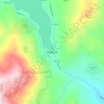
Name: Topografische Karte Newbury, Höhe, Relief.
Durchschnittliche Höhe: 456 m
Minimale Höhe: 237 m
Maximale Höhe: 804 m
According to the United States Census Bureau, the town has a total area of 38.1 square miles (98.7 km2), of which 35.8 square miles (92.8 km2) are land and 2.3 square miles (5.9 km2) are water, comprising 5.94% of the town. Mount Sunapee, the highest point in town, has an elevation of 2,726 feet (831 m) above sea level. The northern half of the town drains into Lake Sunapee, which in turns drains west via the Sugar River into the Connecticut River and thence to Long Island Sound. The southern half of the town, including the eastern side of Mount Sunapee, drains via Andrew Brook and the West Branch of the Warner River to the Warner River, which flows east to the Contoocook River, then into the Merrimack River, and ultimately to the Gulf of Maine.