
Topografische Karte Beaver Brook
Interaktive Karte
Klicken Sie auf die Karte, um die Höhe anzuzeigen.
Über diese Karte
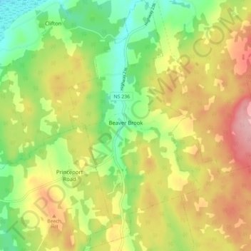
Name: Topografische Karte Beaver Brook, Höhe, Relief.
Durchschnittliche Höhe: 71 m
Minimale Höhe: 0 m
Maximale Höhe: 151 m
Andere topografische Karten
Klicken Sie auf eine Karte, um ihre Topografie, ihre Höhe und ihr Relief anzuzeigen.
MacKay Siding
Canada > Nova Scotia > Municipality of Colchester
MacKay Siding, Municipality of Colchester, Colchester County, Nova Scotia, Canada
Durchschnittliche Höhe: 29 m
East Earltown
Canada > Nova Scotia > Municipality of Colchester
East Earltown, Municipality of Colchester, Colchester County, Nova Scotia, Canada
Durchschnittliche Höhe: 111 m
Brentwood
Canada > Nova Scotia > Municipality of Colchester
Brentwood, Municipality of Colchester, Colchester County, Nova Scotia, Canada
Durchschnittliche Höhe: 47 m
Fort Ellis
Canada > Nova Scotia > Municipality of Colchester
Fort Ellis, Municipality of Colchester, Colchester County, Nova Scotia, Canada
Durchschnittliche Höhe: 28 m
Staples Brook
Canada > Nova Scotia > Municipality of Colchester
Staples Brook, Belmont, Municipality of Colchester, Colchester County, Nova Scotia, Canada
Durchschnittliche Höhe: 69 m
Central North River
Canada > Nova Scotia > Municipality of Colchester
Central North River, Municipality of Colchester, Colchester County, Nova Scotia, Canada
Durchschnittliche Höhe: 111 m
Pembroke
Canada > Nova Scotia > Municipality of Colchester
Pembroke, Municipality of Colchester, Colchester County, Nova Scotia, Canada
Durchschnittliche Höhe: 110 m
Keeble
Canada > Nova Scotia > Municipality of Colchester > Keble
Keeble, Keble, Municipality of Colchester, Colchester County, Nova Scotia, Canada
Durchschnittliche Höhe: 33 m
Brookfield
Canada > Nova Scotia > Municipality of Colchester
Brookfield, Municipality of Colchester, Colchester County, Nova Scotia, B0N 1C0, Canada
Durchschnittliche Höhe: 98 m
Lanesville
Canada > Nova Scotia > Municipality of Colchester
Lanesville, Municipality of Colchester, Colchester County, Nova Scotia, Canada
Durchschnittliche Höhe: 52 m
Union
Canada > Nova Scotia > Municipality of Colchester
Union, Greenfield, Municipality of Colchester, Colchester County, Nova Scotia, B6L 3L9, Canada
Durchschnittliche Höhe: 124 m
Onslow Mountain
Canada > Nova Scotia > Municipality of Colchester > Onslow Mountain
Onslow Mountain, Municipality of Colchester, Colchester County, Nova Scotia, Canada
Durchschnittliche Höhe: 115 m
West New Annan
Canada > Nova Scotia > Municipality of Colchester
West New Annan, Municipality of Colchester, Colchester County, Nova Scotia, Canada
Durchschnittliche Höhe: 138 m
Clifton
Canada > Nova Scotia > Municipality of Colchester > Clifton
Clifton, Municipality of Colchester, Colchester County, Nova Scotia, Canada
Durchschnittliche Höhe: 31 m
Shubenacadie East
Canada > Nova Scotia > Municipality of Colchester > Shubenacadie East
Shubenacadie East, Municipality of Colchester, Colchester County, Nova Scotia, Canada
Durchschnittliche Höhe: 28 m
Earltown
Canada > Nova Scotia > Municipality of Colchester
Earltown, Municipality of Colchester, Colchester County, Nova Scotia, Canada
Durchschnittliche Höhe: 202 m
Valley Station
Canada > Nova Scotia > Municipality of Colchester > Valley Station
Valley Station, Valley, Municipality of Colchester, Colchester County, Nova Scotia, B6L 2Y2, Canada
Durchschnittliche Höhe: 60 m
Bass River
Canada > Nova Scotia > Municipality of Colchester
Bass River, Municipality of Colchester, Colchester County, Nova Scotia, B0M 1E0, Canada
Durchschnittliche Höhe: 145 m
Upper Brookfield
Canada > Nova Scotia > Municipality of Colchester > Upper Brookfield
Upper Brookfield, Brookfield, Municipality of Colchester, Colchester County, Nova Scotia, B0N 1C0, Canada
Durchschnittliche Höhe: 62 m
Economy
Canada > Nova Scotia > Municipality of Colchester
Economy, Municipality of Colchester, Colchester County, Nova Scotia, B0M 1J0, Canada
Durchschnittliche Höhe: 93 m