
Topografische Karte San Vicente de Toranzo
Interaktive Karte
Klicken Sie auf die Karte, um die Höhe anzuzeigen.
Über diese Karte
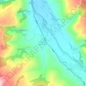
Name: Topografische Karte San Vicente de Toranzo, Höhe, Relief.
Durchschnittliche Höhe: 280 m
Minimale Höhe: 124 m
Maximale Höhe: 608 m
San Vicente de Toranzo es la capital del municipio de Corvera de Toranzo (Cantabria, España). En el año 2016 contaba con una población de 374 habitantes (INE). La localidad se encuentra a 168 metros de altitud sobre el nivel del mar.
Andere topografische Karten
Klicken Sie auf eine Karte, um ihre Topografie, ihre Höhe und ihr Relief anzuzeigen.
Sel del Tojo
España > Cantabria > Valles Pasiegos > Corvera de Toranzo > Sel del Tojo
Sel del Tojo, Corvera de Toranzo, Valles Pasiegos, Cantabria, 39682, España
Durchschnittliche Höhe: 406 m
Castillo Pedroso
España > Cantabria > Valles Pasiegos > Corvera de Toranzo > Castillo Pedroso
Castillo Pedroso, Corvera de Toranzo, Valles Pasiegos, Cantabria, 39699, España
Durchschnittliche Höhe: 426 m