Geolokalisieren
👉 Easily get elevation data in JSON, GeoTIFF and KML formats using Elevation API
Vielen Dank für die Unterstützung dieser Website ❤️
Spenden

Topografische Karte Nowshera

Klicken Sie auf die Karte, um die Höhe anzuzeigen.

👉 Easily get elevation data in JSON, GeoTIFF and KML formats using Elevation API
Vielen Dank für die Unterstützung dieser Website ❤️
Spenden

Nowshera

Given its spatial and demographic extent, Nowshera has been given the status of a Sub-District. It is a beautiful place with a number of tourist attractions including the fort of Mangla Devi, holy cave temple of Mangla Mata, Central Gurudwara of Sikhs in Nonial, Qila Darhal and other Dargahs and temples. The literacy rate of Nowshera is very high with low male-female literacy gap that shows that there is deep inclination of people towards education. It has an average elevation of 1,575 metres (5,167 feet).

Wikipedia (CC-BY-SA 3.0)

👉 Easily get elevation data in JSON, GeoTIFF and KML formats using Elevation API
Vielen Dank für die Unterstützung dieser Website ❤️
Spenden

Über diese Karte

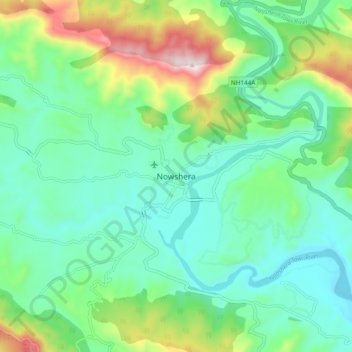
Name: Topografische Karte Nowshera, Höhe, Relief.

Ort: Nowshera, Nowshehra Tehsil, Rajouri District, Jammu and Kashmir, 185151, India (33.11751 74.20039 33.19751 74.28039)

Durchschnittliche Höhe: 668 m

Minimale Höhe: 501 m

Maximale Höhe: 1.119 m

Rüsten Sie sich für Ihr nächstes Abenteuer:

🧠Survival Bücher - Outdoor Überlebenswissen
🔦LED Fahrradlicht Set - StVZO-konforme Beleuchtung für Sicherheit bei Nacht
🧢Outdoor Mütze - Schutz vor Sonne und Kälte
📟Notfall-Satelliten-Messenger - Sicherheit durch weltweite Notruffunktion per Satellit
🥘Camping Kochgeschirr Set - Stapelbare Töpfe und Pfannen aus Aluminium

Als Amazon-Partner verdient diese Website an qualifizierten Käufen, ohne dass Ihnen zusätzliche Kosten entstehen.