
Topografische Karte Rosseau
Interaktive Karte
Klicken Sie auf die Karte, um die Höhe anzuzeigen.
Über diese Karte
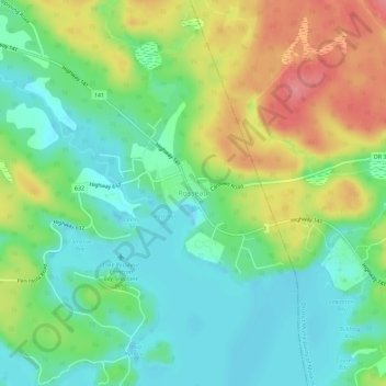
Name: Topografische Karte Rosseau, Höhe, Relief.
Durchschnittliche Höhe: 257 m
Minimale Höhe: 222 m
Maximale Höhe: 317 m
Andere topografische Karten
Klicken Sie auf eine Karte, um ihre Topografie, ihre Höhe und ihr Relief anzuzeigen.
Otter Lake
Canada > Ontario > Parry Sound District > Seguin Township
Otter Lake, Seguin Township, Parry Sound District, Central Ontario, Ontario, Canada
Durchschnittliche Höhe: 227 m
Humphrey
Canada > Ontario > Parry Sound District > Seguin Township
Humphrey, Seguin Township, Parry Sound District, Central Ontario, Ontario, Canada
Durchschnittliche Höhe: 255 m
Salmon Lake
Canada > Ontario > Parry Sound District > Seguin Township
Salmon Lake, Seguin Township, Parry Sound District, Central Ontario, Ontario, Canada
Durchschnittliche Höhe: 220 m
Orrville
Canada > Ontario > Parry Sound District > Seguin Township > Orrville
Orrville, Seguin Township, Parry Sound District, Central Ontario, Ontario, Canada
Durchschnittliche Höhe: 262 m
Hoben Lake
Canada > Ontario > Parry Sound District > Seguin Township
Hoben Lake, Seguin Township, Parry Sound District, Central Ontario, Ontario, Canada
Durchschnittliche Höhe: 249 m
Seeley Bay
Canada > Ontario > Parry Sound District > Seguin Township
Seeley Bay, Seguin Township, Parry Sound District, Central Ontario, Ontario, Canada
Durchschnittliche Höhe: 238 m
Clear Lake
Canada > Ontario > Parry Sound District > Seguin Township
Clear Lake, Seguin Township, Parry Sound District, Central Ontario, Ontario, Canada
Durchschnittliche Höhe: 252 m