
Topografische Karte Grady County
Interaktive Karte
Klicken Sie auf die Karte, um die Höhe anzuzeigen.
Über diese Karte
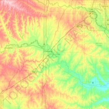
Name: Topografische Karte Grady County, Höhe, Relief.
Ort: Grady County, Oklahoma, United States (34.68122 -98.09601 35.37775 -97.66814)
Durchschnittliche Höhe: 376 m
Minimale Höhe: 288 m
Maximale Höhe: 510 m
Andere topografische Karten
Klicken Sie auf eine Karte, um ihre Topografie, ihre Höhe und ihr Relief anzuzeigen.
Fort Gibson
United States > Oklahoma > Muskogee County > Fort Gibson
Fort Gibson, Muskogee County, Oklahoma, United States
Durchschnittliche Höhe: 162 m
Olustee
United States > Oklahoma > Jackson County
Olustee, Jackson County, Oklahoma, 73560, United States
Durchschnittliche Höhe: 405 m
May
United States > Oklahoma > Harper County
May, Harper County, Oklahoma, United States
Durchschnittliche Höhe: 626 m
Wandel
United States > Oklahoma > Kingfisher County
Wandel, Kingfisher County, Oklahoma, United States
Durchschnittliche Höhe: 307 m
Buffalo
United States > Oklahoma > Harper County
Buffalo, Harper County, Oklahoma, 73834, United States
Durchschnittliche Höhe: 551 m
Ada
United States > Oklahoma > Pontotoc County
Ada, Pontotoc County, Oklahoma, 74820, United States
Durchschnittliche Höhe: 300 m
Stilwell
United States > Oklahoma > Adair County
Stilwell, Adair County, Oklahoma, 74960, United States
Durchschnittliche Höhe: 352 m
Baron
United States > Oklahoma > Adair County
Baron, Adair County, Oklahoma, United States
Durchschnittliche Höhe: 296 m
Proctor
United States > Oklahoma > Adair County
Proctor, Adair County, Oklahoma, United States
Durchschnittliche Höhe: 272 m
Christie
United States > Oklahoma > Adair County
Christie, Adair County, Oklahoma, United States
Durchschnittliche Höhe: 283 m
Redden
United States > Oklahoma > Atoka County
Redden, Atoka County, Oklahoma, United States
Durchschnittliche Höhe: 220 m
Clinton
United States > Oklahoma > Custer County
Clinton, Custer County, Oklahoma, 73601, United States
Durchschnittliche Höhe: 481 m
Creek County
Creek County, Oklahoma, United States
Durchschnittliche Höhe: 255 m
Duncan
United States > Oklahoma > Stephens County
Duncan, Stephens County, Oklahoma, 73533, United States
Durchschnittliche Höhe: 350 m
Finley
United States > Oklahoma > Pushmataha County
Finley, Pushmataha County, Oklahoma, 74543, United States
Durchschnittliche Höhe: 155 m
Bartlesville
United States > Oklahoma > Washington County
Bartlesville, Washington County, Oklahoma, United States
Durchschnittliche Höhe: 231 m
Sand Springs
United States > Oklahoma > Tulsa County
Sand Springs, Tulsa County, Oklahoma, United States
Durchschnittliche Höhe: 238 m
Daly Hill
United States > Oklahoma > Comanche County
Daly Hill, Comanche County, Oklahoma, United States
Durchschnittliche Höhe: 396 m
Jones
United States > Oklahoma > Oklahoma County
Jones, Oklahoma County, Oklahoma, United States
Durchschnittliche Höhe: 354 m
Heavener
United States > Oklahoma > Le Flore County
Heavener, Le Flore County, Oklahoma, 74937, United States
Durchschnittliche Höhe: 193 m
Andes Mountain
United States > Oklahoma > Sequoyah County
Andes Mountain, Sequoyah County, Oklahoma, 74945, United States
Durchschnittliche Höhe: 202 m
Jackson Hole
United States > Oklahoma > Comanche County
Jackson Hole, Comanche County, Oklahoma, United States
Durchschnittliche Höhe: 406 m
Scaffold Mountain
United States > Oklahoma > Pittsburg County
Scaffold Mountain, Pittsburg County, Oklahoma, United States
Durchschnittliche Höhe: 283 m
Hooker
United States > Oklahoma > Texas County
Hooker, Texas County, Oklahoma, 73945, United States
Durchschnittliche Höhe: 911 m
Tishomingo
United States > Oklahoma > Johnston County
Tishomingo, Johnston County, Oklahoma, 73460, United States
Durchschnittliche Höhe: 214 m
Choctaw County
Choctaw County, Oklahoma, United States
Durchschnittliche Höhe: 161 m
Harper County
Harper County, Oklahoma, United States
Durchschnittliche Höhe: 610 m
Cotton County
Cotton County, Oklahoma, United States
Durchschnittliche Höhe: 309 m
Dustin
United States > Oklahoma > Hughes County
Dustin, Hughes County, Oklahoma, 74839, United States
Durchschnittliche Höhe: 217 m
Cashion
United States > Oklahoma > Kingfisher County
Cashion, Kingfisher County, Oklahoma, 73016, United States
Durchschnittliche Höhe: 339 m
Del City
United States > Oklahoma > Oklahoma County
Del City, Oklahoma County, Oklahoma, 73115, United States
Durchschnittliche Höhe: 369 m
Dewey County
Dewey County, Oklahoma, United States
Durchschnittliche Höhe: 561 m
Sapulpa
United States > Oklahoma > Creek County
Sapulpa, Creek County, Oklahoma, United States
Durchschnittliche Höhe: 232 m
Honey Springs Battlefield
United States > Oklahoma > McIntosh County > Rentiesville
Honey Springs Battlefield, N4232 Road, Rentiesville, McIntosh County, Oklahoma, 74459, United States
Durchschnittliche Höhe: 185 m
Vinita
United States > Oklahoma > Craig County
Vinita, Craig County, Oklahoma, 74301, United States
Durchschnittliche Höhe: 213 m
Checotah
United States > Oklahoma > McIntosh County
Checotah, McIntosh County, Oklahoma, 74426, United States
Durchschnittliche Höhe: 189 m
Verdigris
United States > Oklahoma > Rogers County
Verdigris, Rogers County, Oklahoma, United States
Durchschnittliche Höhe: 184 m
Oklahoma City
United States > Oklahoma > Oklahoma County
Oklahoma City, Oklahoma County, Oklahoma, United States
Durchschnittliche Höhe: 362 m
Broken Bow Lake
United States > Oklahoma > McCurtain County
Broken Bow Lake, McCurtain County, Oklahoma, United States
Durchschnittliche Höhe: 158 m
Kingston
United States > Oklahoma > Marshall County
Kingston, Marshall County, Oklahoma, United States
Durchschnittliche Höhe: 239 m
Blue
United States > Oklahoma > Bryan County
Blue, Bryan County, Oklahoma, 74726, United States
Durchschnittliche Höhe: 177 m
Skiatook
United States > Oklahoma > Osage County
Skiatook, Osage County, Oklahoma, 74070, United States
Durchschnittliche Höhe: 222 m
Broken Bow
United States > Oklahoma > McCurtain County
Broken Bow, McCurtain County, Oklahoma, United States
Durchschnittliche Höhe: 155 m
Piedmont
United States > Oklahoma > Canadian County
Piedmont, Canadian County, Oklahoma, 73078, United States
Durchschnittliche Höhe: 362 m
Hugo
United States > Oklahoma > Choctaw County
Hugo, Choctaw County, Oklahoma, 74743, United States
Durchschnittliche Höhe: 155 m
South East Corner Landing Strip
United States > Oklahoma > Comanche County
South East Corner Landing Strip, Comanche County, Oklahoma, United States
Durchschnittliche Höhe: 383 m
Tom London Dam
United States > Oklahoma > Cleveland County
Tom London Dam, Cleveland County, Oklahoma, United States
Durchschnittliche Höhe: 324 m
Payne County
Payne County, Oklahoma, United States
Durchschnittliche Höhe: 290 m
Little Axe
United States > Oklahoma > Cleveland County > Norman
Little Axe, Norman, Cleveland County, Oklahoma, United States
Durchschnittliche Höhe: 321 m
Nashoba
United States > Oklahoma > Pushmataha County
Nashoba, Pushmataha County, Oklahoma, 74558, United States
Durchschnittliche Höhe: 233 m