
Topografische Karte Ettumanoor
Interaktive Karte
Klicken Sie auf die Karte, um die Höhe anzuzeigen.
Über diese Karte
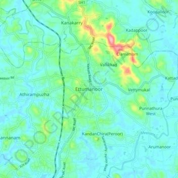
Name: Topografische Karte Ettumanoor, Höhe, Relief.
Ort: Ettumanoor, Kottayam, Kerala, 686631, India (9.63018 76.51778 9.71018 76.59778)
Durchschnittliche Höhe: 22 m
Minimale Höhe: -1 m
Maximale Höhe: 123 m
Andere topografische Karten
Klicken Sie auf eine Karte, um ihre Topografie, ihre Höhe und ihr Relief anzuzeigen.
Sankranthi
India > Kerala > Kottayam > Kottayam
Sankranthi, Kumaranalloor, Kottayam, Kerala, 686028, India
Durchschnittliche Höhe: 15 m
Thiruvanchoor
India > Kerala > Kottayam > Thiruvanchoor
Thiruvanchoor, Kottayam, Kerala, 686032, India
Durchschnittliche Höhe: 11 m
Illickal Thazhe
India > Kerala > Kottayam > Kozhikombu > Illickal Thazhe
Illickal Thazhe, Kozhikombu, Kottayam, Kerala, 686635, India
Durchschnittliche Höhe: 46 m