
Topografische Karte Hendersonville
Interaktive Karte
Klicken Sie auf die Karte, um die Höhe anzuzeigen.
Über diese Karte
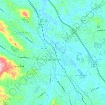
Name: Topografische Karte Hendersonville, Höhe, Relief.
Durchschnittliche Höhe: 670 m
Minimale Höhe: 623 m
Maximale Höhe: 905 m
Andere topografische Karten
Klicken Sie auf eine Karte, um ihre Topografie, ihre Höhe und ihr Relief anzuzeigen.
Westwood
United States > North Carolina > Henderson County
Westwood, Henderson County, North Carolina, 28738, United States
Durchschnittliche Höhe: 666 m
Wildwood Heights
United States > North Carolina > Henderson County > Laurel Park
Wildwood Heights, Laurel Park, Henderson County, North Carolina, 28739, United States
Durchschnittliche Höhe: 757 m
Etowah
United States > North Carolina > Henderson County
Etowah, Henderson County, North Carolina, 28729, United States
Durchschnittliche Höhe: 652 m
Flat Rock Forest
United States > North Carolina > Henderson County > Flat Rock > Flat Rock Forest
Flat Rock Forest, Flat Rock, Henderson County, North Carolina, 28726, United States
Durchschnittliche Höhe: 681 m
Mills River
United States > North Carolina > Henderson County > Mills River > Oak Hill Court
Mills River, Oak Hill Court, Mills River, Henderson County, North Carolina, 28759, United States
Durchschnittliche Höhe: 644 m
Claremont
United States > North Carolina > Henderson County > Flat Rock > Claremont
Claremont, Flat Rock, Henderson County, North Carolina, 28726, United States
Durchschnittliche Höhe: 713 m
Horse Shoe
United States > North Carolina > Henderson County > Horse Shoe
Horse Shoe, Henderson County, North Carolina, 28742, United States
Durchschnittliche Höhe: 668 m
Fletcher
United States > North Carolina > Henderson County
Fletcher, Henderson County, North Carolina, 28732, United States
Durchschnittliche Höhe: 666 m