
Topografische Karte Jayapura
Interaktive Karte
Klicken Sie auf die Karte, um die Höhe anzuzeigen.
Über diese Karte
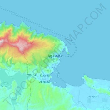
Name: Topografische Karte Jayapura, Höhe, Relief.
Ort: Jayapura, Papua, 99111, Indonesia (-2.69875 140.54374 -2.37875 140.86374)
Durchschnittliche Höhe: 149 m
Minimale Höhe: 0 m
Maximale Höhe: 1.660 m
The topography of Jayapura varies from valleys to hills, plateaus, and mountains up to 700 metres (2,300 ft) above sea level. Jayapura overlooks the Yos Sudarso Bay. Jayapura is about 94,000 hectares (230,000 acres) in area, and is divided into five districts. Around 30% of the area is inhabited, with the remainder consisting of a rough terrain, swamps, and protected forest. The average temperature is 29–31.8 °C (84.2–89.2 °F).