
Spenden
Rüsten Sie sich für Ihr nächstes Abenteuer:
Als Amazon-Partner verdient diese Website an qualifizierten Käufen, ohne dass Ihnen zusätzliche Kosten entstehen.
Topografische Karte L'Ile
Klicken Sie auf die Karte, um die Höhe anzuzeigen.
Spenden
Rüsten Sie sich für Ihr nächstes Abenteuer:
Als Amazon-Partner verdient diese Website an qualifizierten Käufen, ohne dass Ihnen zusätzliche Kosten entstehen.
Über diese Karte
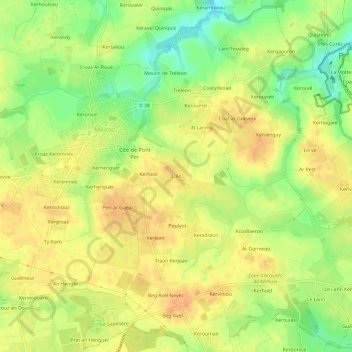
Name: Topografische Karte L'Ile, Höhe, Relief.
Durchschnittliche Höhe: 87 m
Minimale Höhe: 65 m
Maximale Höhe: 100 m
Spenden
Rüsten Sie sich für Ihr nächstes Abenteuer:
Als Amazon-Partner verdient diese Website an qualifizierten Käufen, ohne dass Ihnen zusätzliche Kosten entstehen.
Andere topografische Karten
Klicken Sie auf eine Karte, um ihre Topografie, ihre Höhe und ihr Relief anzuzeigen.
Milizac
France > Bretagne > Finistère > Milizac-Guipronvel
Milizac se trouve sur le plateau du Léon qui forme une pénéplaine cristalline (granit de Saint-Renan, gneiss et micaschiste) : la majeure partie du finage communal est entre 80 et 100 mètres d'altitude (le point culminant est à 102 mètres à l'extrême nord-ouest de la commune, près de Kervenan) ;…
Durchschnittliche Höhe: 78 m
Guipronvel
France > Bretagne > Finistère > Milizac-Guipronvel
Formée d'un morceau du plateau du Léon (une pénéplaine cristalline constituée de granit de Saint-Renan, gneiss et micaschiste), l'ancienne commune de Guipronvel est en pente douce vers le nord (les altitudes les plus élevées se trouvent dans le sud du finage communal : 89 mètres entre Gouézou et Le…
Durchschnittliche Höhe: 65 m