
Topografische Karte Aberdeen
Interaktive Karte
Klicken Sie auf die Karte, um die Höhe anzuzeigen.
Über diese Karte
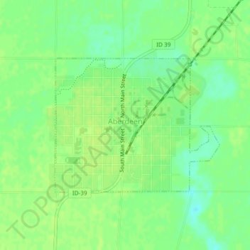
Name: Topografische Karte Aberdeen, Höhe, Relief.
Ort: Aberdeen, Bingham County, Idaho, 83210, United States (42.93691 -112.84870 42.95138 -112.82435)
Durchschnittliche Höhe: 1.341 m
Minimale Höhe: 1.332 m
Maximale Höhe: 1.345 m
Aberdeen is located at 42°56′36″N 112°50′22″W / 42.94333°N 112.83944°W / 42.94333; -112.83944 (42.943405, -112.839322), at an elevation of 4,403 feet (1,342 m) above sea level. According to the United States Census Bureau, the city has a total area of 1.03 square miles (2.67 km2), all of it land.
Andere topografische Karten
Klicken Sie auf eine Karte, um ihre Topografie, ihre Höhe und ihr Relief anzuzeigen.
Blackfoot
United States > Idaho > Bingham County
Blackfoot, Bingham County, Idaho, 83221, United States
Durchschnittliche Höhe: 1.371 m
Atomic City
United States > Idaho > Bingham County
Atomic City, Bingham County, Idaho, 83215, United States
Durchschnittliche Höhe: 1.533 m
Fort Hall
United States > Idaho > Bingham County
Fort Hall, Bingham County, Idaho, 83203, United States
Durchschnittliche Höhe: 1.356 m