
Topografische Karte Chachani Volcano
Interaktive Karte
Klicken Sie auf die Karte, um die Höhe anzuzeigen.
Über diese Karte
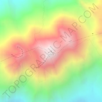
Name: Topografische Karte Chachani Volcano, Höhe, Relief.
Durchschnittliche Höhe: 5.562 m
Minimale Höhe: 5.032 m
Maximale Höhe: 6.071 m
The volcano lies in the Andes of southern Peru, 22 kilometres (14 mi) northwest of Arequipa and north of the Arequipa Airport; the city of Arequipa is situated on the foot of Chachani and El Misti volcanoes. The road from Arequipa to Chivay runs along the southeastern foot of Chachani, and a dirt road reaches to an elevation of 5,000 metres (16,000 ft). It is considered to be one of the most easily climbed mountains between 6,000 - 7,000 m high, although acclimatization and good physical health are required to ascend it.