Geolokalisieren
👉 Easily get elevation data in JSON, GeoTIFF and KML formats using Elevation API
Vielen Dank für die Unterstützung dieser Website ❤️
Spenden

Rüsten Sie sich für Ihr nächstes Abenteuer:

Als Amazon-Partner verdient diese Website an qualifizierten Käufen, ohne dass Ihnen zusätzliche Kosten entstehen.

Topografische Karte Western Isles

Klicken Sie auf die Karte, um die Höhe anzuzeigen.

👉 Easily get elevation data in JSON, GeoTIFF and KML formats using Elevation API
Vielen Dank für die Unterstützung dieser Website ❤️
Spenden

Rüsten Sie sich für Ihr nächstes Abenteuer:

Als Amazon-Partner verdient diese Website an qualifizierten Käufen, ohne dass Ihnen zusätzliche Kosten entstehen.

Über diese Karte

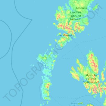
Name: Topografische Karte Western Isles, Höhe, Relief.

Ort: Western Isles, Scotland, HS6 5BH, United Kingdom (57.02667 -7.80667 58.30667 -6.52667)

Durchschnittliche Höhe: 23 m

Minimale Höhe: -1 m

Maximale Höhe: 905 m

Andere topografische Karten

Klicken Sie auf eine Karte, um ihre Topografie, ihre Höhe und ihr Relief anzuzeigen.

City of Edinburgh

United Kingdom > Scotland

Edinburgh has been popularly called the Athens of the North since the early 19th century. References to Athens, such as Athens of Britain and Modern Athens, had been made as early as the 1760s. The similarities were seen to be topographical but also intellectual. Edinburgh's Castle Rock reminded returning…

Durchschnittliche Höhe: 118 m

Skye

United Kingdom > Scotland > Highland

Beyond Loch Snizort to the west of Trotternish is the Waternish peninsula, which ends in Ardmore Point's double rock arch. Duirinish peninsula is separated from Waternish by Loch Dunvegan, which contains the island of Isay. It is ringed by sea cliffs that reach 296 metres (971 feet) on the west at Waterstein…

Durchschnittliche Höhe: 63 m

Dumfries and Galloway

United Kingdom > Scotland

Durchschnittliche Höhe: 163 m

Aberdeen City

United Kingdom > Scotland

Two weather stations collect climate data for the area, Aberdeen/Dyce Airport, and Craibstone. Both are about 4+1⁄2 miles (7 km) to the north west of the city centre, and given that they are in close proximity to each other, exhibit very similar climatic regimes. Dyce tends to have marginally warmer daytime…

Durchschnittliche Höhe: 46 m

Vielen Dank für die Unterstützung dieser Website ❤️
Spenden

Rüsten Sie sich für Ihr nächstes Abenteuer:

Als Amazon-Partner verdient diese Website an qualifizierten Käufen, ohne dass Ihnen zusätzliche Kosten entstehen.

Lewis and Harris

United Kingdom > Scotland

Durchschnittliche Höhe: 28 m

Glasgow City

United Kingdom > Scotland

Durchschnittliche Höhe: 64 m

Highland

United Kingdom > Scotland

Durchschnittliche Höhe: 183 m

Moray

United Kingdom > Scotland

Durchschnittliche Höhe: 280 m

Cairngorms National Park

United Kingdom > Scotland

Durchschnittliche Höhe: 431 m

Loch Lomond and The Trossachs National Park

United Kingdom > Scotland > Stirling

The park straddles the Highland Boundary Fault, which divides it into two distinct regions - lowland and highland - that differ in underlying geology, soil types and topography. The change in rock type can most clearly be seen at Loch Lomond itself, as the fault runs across the islands of Inchmurrin, Creinch,…

Durchschnittliche Höhe: 291 m

Isle of Rum

United Kingdom > Scotland > Highland > Kinloch

The island's relief is spectacular, a 19th-century commentator remarking that "the interior is one heap of rude mountains, scarcely possessing an acre of level land". This combination of geology and topography make for less than ideal agricultural conditions, and it is doubtful that more than one tenth of the…

Durchschnittliche Höhe: 118 m

Sanday

United Kingdom > Scotland > Orkney Islands > Kettletoft

In the mid-17th century an annexe to Blaeu's Atlas Novus of Scotland recorded that Sanday's low lying topography meant that "shipwreck often occurs to those who sail there at night. The inhabitants of Sanday earnestly and often desire this to happen, so that they get a supply of material for fire from the…

Durchschnittliche Höhe: 2 m

Vielen Dank für die Unterstützung dieser Website ❤️
Spenden

Rüsten Sie sich für Ihr nächstes Abenteuer:

Als Amazon-Partner verdient diese Website an qualifizierten Käufen, ohne dass Ihnen zusätzliche Kosten entstehen.

Northfield

United Kingdom > Scotland > Aberdeen City

Durchschnittliche Höhe: 91 m

Edinburgh Castle

United Kingdom > Scotland > City of Edinburgh

Durchschnittliche Höhe: 65 m

Dunfermline

United Kingdom > Scotland > Fife > Dunfermline

Durchschnittliche Höhe: 80 m

Vielen Dank für die Unterstützung dieser Website ❤️
Spenden

Rüsten Sie sich für Ihr nächstes Abenteuer:

Als Amazon-Partner verdient diese Website an qualifizierten Käufen, ohne dass Ihnen zusätzliche Kosten entstehen.

Rogart

United Kingdom > Scotland > Highland

Durchschnittliche Höhe: 236 m

Moray

United Kingdom > Scotland

Durchschnittliche Höhe: 281 m

Shetland

United Kingdom > Scotland

Walter Scott's 1822 novel The Pirate is set in "a remote part of Shetland", and was inspired by his 1814 visit to the islands. The name Jarlshof meaning "Earl's Mansion" is a coinage of his. Robert Cowie, a doctor born in Lerwick published the 1874 work.Shetland: Descriptive and Historical; Being a Graduation…

Durchschnittliche Höhe: 4 m

Hebrides

United Kingdom > Scotland

Durchschnittliche Höhe: 94 m

Vielen Dank für die Unterstützung dieser Website ❤️
Spenden

Rüsten Sie sich für Ihr nächstes Abenteuer:

Als Amazon-Partner verdient diese Website an qualifizierten Käufen, ohne dass Ihnen zusätzliche Kosten entstehen.

Hirta

United Kingdom > Scotland > Western Isles

Durchschnittliche Höhe: 58 m

Fife

United Kingdom > Scotland

Durchschnittliche Höhe: 67 m

South Lanarkshire

United Kingdom > Scotland

Durchschnittliche Höhe: 289 m

East Lothian

United Kingdom > Scotland

Durchschnittliche Höhe: 132 m

Vielen Dank für die Unterstützung dieser Website ❤️
Spenden

South Ayrshire

United Kingdom > Scotland

The number of hours of natural sunshine in South Ayrshire is controlled by the length of day and by cloudiness. In general, December is the dullest month and May or June the sunniest. Sunshine duration decreases with increasing altitude, increasing latitude and distance from the coast. Local topography also…

Durchschnittliche Höhe: 151 m

Isle of Arran

United Kingdom > Scotland > North Ayrshire

The island has three endemic species of tree, the Arran whitebeams. These trees are the Scottish or Arran whitebeam (Sorbus arranensis), the bastard mountain ash or cut-leaved whitebeam (Sorbus pseudofennica) and the Catacol whitebeam (Sorbus pseudomeinichii). If rarity is measured by numbers alone they are…

Durchschnittliche Höhe: 98 m

Quiraing

United Kingdom > Scotland > Highland

Durchschnittliche Höhe: 298 m

Orkney Islands

United Kingdom > Scotland

The southern group of islands surrounds Scapa Flow. Hoy, to the west, is the second largest of the Orkney Isles and Ward Hill at its northern end is the highest elevation in the archipelago. The Old Man of Hoy is a well-known seastack. Graemsay and Flotta are both linked by ferry to the Mainland and Hoy, and…

Durchschnittliche Höhe: 7 m

Midlothian

United Kingdom > Scotland

Durchschnittliche Höhe: 236 m

North Lanarkshire

United Kingdom > Scotland

Durchschnittliche Höhe: 149 m

Angus

United Kingdom > Scotland

Angus can be split into three geographic areas. To the north and west, the topography is mountainous. This is the area of the Grampian Mountains, Mounth hills and Five Glens of Angus, which is sparsely populated and where the main industry is hill farming. Glas Maol – the highest point in Angus at 1,068 m…

Durchschnittliche Höhe: 254 m

West Lothian

United Kingdom > Scotland

Durchschnittliche Höhe: 184 m

Vielen Dank für die Unterstützung dieser Website ❤️
Spenden

Rüsten Sie sich für Ihr nächstes Abenteuer:

Als Amazon-Partner verdient diese Website an qualifizierten Käufen, ohne dass Ihnen zusätzliche Kosten entstehen.

Dundee City

United Kingdom > Scotland

Durchschnittliche Höhe: 74 m

Argyll and Bute

United Kingdom > Scotland

Durchschnittliche Höhe: 84 m

Caithness

United Kingdom > Scotland

Caithness extends about 30 miles (48 km) north-south and about 30 miles (48 km) east-west, with a roughly triangular-shaped area of about 712 sq mi (1,840 km2). The topography is generally flat, in contrast to the majority of the remainder of the North of Scotland. Until the latter part of the 20th century…

Durchschnittliche Höhe: 79 m

Perth and Kinross

United Kingdom > Scotland

Durchschnittliche Höhe: 338 m

Vielen Dank für die Unterstützung dieser Website ❤️
Spenden

Rüsten Sie sich für Ihr nächstes Abenteuer:

Als Amazon-Partner verdient diese Website an qualifizierten Käufen, ohne dass Ihnen zusätzliche Kosten entstehen.

Scottish Borders

United Kingdom > Scotland

Durchschnittliche Höhe: 257 m

Renfrewshire

United Kingdom > Scotland

Durchschnittliche Höhe: 104 m

Aberdeenshire

United Kingdom > Scotland

Durchschnittliche Höhe: 199 m

North Ayrshire

United Kingdom > Scotland

Durchschnittliche Höhe: 80 m

Vielen Dank für die Unterstützung dieser Website ❤️
Spenden

Rüsten Sie sich für Ihr nächstes Abenteuer:

Als Amazon-Partner verdient diese Website an qualifizierten Käufen, ohne dass Ihnen zusätzliche Kosten entstehen.

East Ayrshire

United Kingdom > Scotland

East Ayrshire is located on the west coat of Scotland, sharing borders with the following neighbouring council areas; North Ayrshire, South Ayrshire, Dumfries and Galloway, East Renfrewshire and South Lanarkshire. Blackcraig Hill reaches an elevation of 2,298 feet (700 metres), the highest peak in East…

Durchschnittliche Höhe: 225 m

South Queensferry

United Kingdom > Scotland

Durchschnittliche Höhe: 31 m

River Tweed

United Kingdom > Scotland

Durchschnittliche Höhe: 236 m

River Clyde

United Kingdom > Scotland

Durchschnittliche Höhe: 245 m

Vielen Dank für die Unterstützung dieser Website ❤️
Spenden

Rüsten Sie sich für Ihr nächstes Abenteuer:

Als Amazon-Partner verdient diese Website an qualifizierten Käufen, ohne dass Ihnen zusätzliche Kosten entstehen.

Inchmickery

United Kingdom > Scotland

Durchschnittliche Höhe: 0 m

Ailsa Craig

United Kingdom > Scotland

In a small glen above Ailsa Castle, a small freshwater body known as the Garry Loch is located at an altitude of 247 m (810 ft), with a depth of at least 17 feet.

Durchschnittliche Höhe: 14 m

Iona

United Kingdom > Scotland

Durchschnittliche Höhe: 9 m

Cairngorms National Park

United Kingdom > Scotland

Durchschnittliche Höhe: 432 m

Vielen Dank für die Unterstützung dieser Website ❤️
Spenden

Rüsten Sie sich für Ihr nächstes Abenteuer:

Als Amazon-Partner verdient diese Website an qualifizierten Käufen, ohne dass Ihnen zusätzliche Kosten entstehen.

Glen Dochart

United Kingdom > Scotland

Durchschnittliche Höhe: 469 m

Falkirk

United Kingdom > Scotland

Durchschnittliche Höhe: 105 m

Denton Burn

United Kingdom > Scotland

Durchschnittliche Höhe: 154 m

Taynish Island

United Kingdom > Scotland

Durchschnittliche Höhe: 11 m

River Kerry

United Kingdom > Scotland

Durchschnittliche Höhe: 118 m

Abhainn a' Ghlinne Ghil

United Kingdom > Scotland

Durchschnittliche Höhe: 138 m

River Dee

United Kingdom > Scotland

Durchschnittliche Höhe: 299 m

River Don

United Kingdom > Scotland

Durchschnittliche Höhe: 257 m

Vielen Dank für die Unterstützung dieser Website ❤️
Spenden

Rüsten Sie sich für Ihr nächstes Abenteuer:

Als Amazon-Partner verdient diese Website an qualifizierten Käufen, ohne dass Ihnen zusätzliche Kosten entstehen.

Papa

United Kingdom > Scotland

Durchschnittliche Höhe: 2 m

Loch Urigill

United Kingdom > Scotland

Durchschnittliche Höhe: 172 m

Highland

United Kingdom > Scotland

Durchschnittliche Höhe: 402 m

Snap

United Kingdom > Scotland

Durchschnittliche Höhe: 3 m

Vielen Dank für die Unterstützung dieser Website ❤️
Spenden

Stirling

United Kingdom > Scotland

Durchschnittliche Höhe: 293 m

East Dunbartonshire

United Kingdom > Scotland

Durchschnittliche Höhe: 161 m

West Dunbartonshire

United Kingdom > Scotland

Durchschnittliche Höhe: 101 m

Clackmannanshire

United Kingdom > Scotland

Durchschnittliche Höhe: 175 m

Vielen Dank für die Unterstützung dieser Website ❤️
Spenden

Rüsten Sie sich für Ihr nächstes Abenteuer:

Als Amazon-Partner verdient diese Website an qualifizierten Käufen, ohne dass Ihnen zusätzliche Kosten entstehen.

Western Isles

United Kingdom > Scotland

Durchschnittliche Höhe: 57 m

East Renfrewshire

United Kingdom > Scotland

Durchschnittliche Höhe: 163 m

Inverclyde

United Kingdom > Scotland

Durchschnittliche Höhe: 141 m

River Spey

United Kingdom > Scotland

Durchschnittliche Höhe: 336 m

Sea of the Hebrides

United Kingdom > Scotland

Durchschnittliche Höhe: 18 m

The Minch

United Kingdom > Scotland

Durchschnittliche Höhe: 63 m

St Magnus' Bay

United Kingdom > Scotland

Durchschnittliche Höhe: 6 m

Balmoral Castle

United Kingdom > Scotland > Aberdeenshire > Ballater

Durchschnittliche Höhe: 342 m

Vielen Dank für die Unterstützung dieser Website ❤️
Spenden

Rüsten Sie sich für Ihr nächstes Abenteuer:

Als Amazon-Partner verdient diese Website an qualifizierten Käufen, ohne dass Ihnen zusätzliche Kosten entstehen.

Tiree

United Kingdom > Scotland > Argyll and Bute > Balemartine

Durchschnittliche Höhe: 3 m

Holyrood Park

United Kingdom > Scotland > City of Edinburgh

Durchschnittliche Höhe: 67 m

Lauriston

United Kingdom > Scotland > Falkirk

Durchschnittliche Höhe: 40 m

Eilean nan Ròn

United Kingdom > Scotland > Argyll and Bute

Durchschnittliche Höhe: 0 m

Vielen Dank für die Unterstützung dieser Website ❤️
Spenden

Rüsten Sie sich für Ihr nächstes Abenteuer:

Als Amazon-Partner verdient diese Website an qualifizierten Käufen, ohne dass Ihnen zusätzliche Kosten entstehen.

Great Cumbrae

United Kingdom > Scotland > North Ayrshire > Millport

Durchschnittliche Höhe: 15 m

Strathbogie

United Kingdom > Scotland > Aberdeenshire > Huntly

Durchschnittliche Höhe: 236 m

Awe Barrage

United Kingdom > Scotland > Argyll and Bute

Durchschnittliche Höhe: 263 m

Beinn Eighe

United Kingdom > Scotland > Highland

Beinn Eighe (Scottish Gaelic for 'file mountain') is a mountain massif in the Torridon area of Wester Ross in the Northwest Highlands of Scotland. Lying south of Loch Maree, it forms a long ridge with many spurs and summits, two of which are classified as Munros: Ruadh-stac Mòr at 1,010 m (3,314 ft) and…

Durchschnittliche Höhe: 633 m

Vielen Dank für die Unterstützung dieser Website ❤️
Spenden

Rüsten Sie sich für Ihr nächstes Abenteuer:

Als Amazon-Partner verdient diese Website an qualifizierten Käufen, ohne dass Ihnen zusätzliche Kosten entstehen.

Cairngorm Mountains

United Kingdom > Scotland > Aberdeenshire

In terms of height, remoteness and the severe and changeable weather, the Cairngorms are the most arduous area in the United Kingdom. The plateau area has a Tundra climate (Köppen ET), and the shattered terrain is more like the high ground in high-arctic Canada or northern Norway than what is often observed…

Durchschnittliche Höhe: 619 m

Loch Trool

United Kingdom > Scotland > Dumfries and Galloway > Caldons

Durchschnittliche Höhe: 190 m

Old Town

United Kingdom > Scotland > City of Edinburgh

Durchschnittliche Höhe: 61 m

East Kilbride

United Kingdom > Scotland > East Kilbride

Durchschnittliche Höhe: 177 m

Vielen Dank für die Unterstützung dieser Website ❤️
Spenden

Rüsten Sie sich für Ihr nächstes Abenteuer:

Als Amazon-Partner verdient diese Website an qualifizierten Käufen, ohne dass Ihnen zusätzliche Kosten entstehen.

Loch Fannich

United Kingdom > Scotland > Highland

Durchschnittliche Höhe: 463 m

the Black Isle

United Kingdom > Scotland > Highland

Durchschnittliche Höhe: 82 m

Erchless Castle

United Kingdom > Scotland > Highland > Struy

Durchschnittliche Höhe: 131 m

Glen Lethnot

United Kingdom > Scotland > Angus

Durchschnittliche Höhe: 365 m

Vielen Dank für die Unterstützung dieser Website ❤️
Spenden

Rüsten Sie sich für Ihr nächstes Abenteuer:

Als Amazon-Partner verdient diese Website an qualifizierten Käufen, ohne dass Ihnen zusätzliche Kosten entstehen.

Castle Lachlan

United Kingdom > Scotland > Argyll and Bute > Lephinmore

Durchschnittliche Höhe: 78 m

Castle Kennedy

United Kingdom > Scotland > Dumfries and Galloway

Durchschnittliche Höhe: 24 m

Aberdour

United Kingdom > Scotland > Fife

Durchschnittliche Höhe: 77 m

Falahill

United Kingdom > Scotland > Scottish Borders

Durchschnittliche Höhe: 307 m

Vielen Dank für die Unterstützung dieser Website ❤️
Spenden

Rüsten Sie sich für Ihr nächstes Abenteuer:

Als Amazon-Partner verdient diese Website an qualifizierten Käufen, ohne dass Ihnen zusätzliche Kosten entstehen.

Glen Lyon

United Kingdom > Scotland > Perth and Kinross

Durchschnittliche Höhe: 461 m

Whitebridge

United Kingdom > Scotland > Highland

Durchschnittliche Höhe: 223 m

Knoydart

United Kingdom > Scotland > Highland > Inverie

Durchschnittliche Höhe: 216 m

Vielen Dank für die Unterstützung dieser Website ❤️
Spenden

Loch Brandy

United Kingdom > Scotland > Angus

Durchschnittliche Höhe: 691 m

Achray Water

United Kingdom > Scotland > Stirling

Durchschnittliche Höhe: 167 m

Scapa Flow

United Kingdom > Scotland > Orkney Islands

Durchschnittliche Höhe: 14 m

Galashiels

United Kingdom > Scotland > Scottish Borders > Galashiels

Durchschnittliche Höhe: 201 m

Vielen Dank für die Unterstützung dieser Website ❤️
Spenden

Rüsten Sie sich für Ihr nächstes Abenteuer:

Als Amazon-Partner verdient diese Website an qualifizierten Käufen, ohne dass Ihnen zusätzliche Kosten entstehen.

Rüsten Sie sich für Ihr nächstes Abenteuer:

📻Kurbelradio für Notfälle - Informationen erhalten, auch ohne Batterien oder Netz
📱Wasserdichte Handyhülle - Schützt das Smartphone vor Regen und Stürzen
🔭Kompaktes Fernglas - Leichtes Glas für Naturbeobachtungen aus der Ferne
📱Outdoor Smartphone Hülle - Schutz für Smartphone unterwegs
📡Outdoor Antenne - Empfangsverbesserung

Als Amazon-Partner verdient diese Website an qualifizierten Käufen, ohne dass Ihnen zusätzliche Kosten entstehen.