
Spenden
Rüsten Sie sich für Ihr nächstes Abenteuer:
Als Amazon-Partner verdient diese Website an qualifizierten Käufen, ohne dass Ihnen zusätzliche Kosten entstehen.
Topografische Karte Gopanpally Tank
Klicken Sie auf die Karte, um die Höhe anzuzeigen.
Spenden
Rüsten Sie sich für Ihr nächstes Abenteuer:
Als Amazon-Partner verdient diese Website an qualifizierten Käufen, ohne dass Ihnen zusätzliche Kosten entstehen.
Über diese Karte
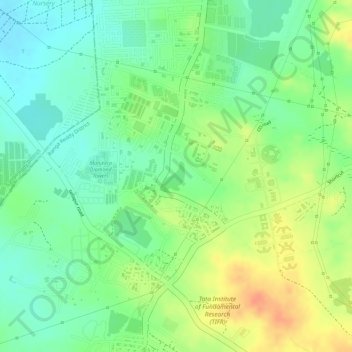
Name: Topografische Karte Gopanpally Tank, Höhe, Relief.
Durchschnittliche Höhe: 577 m
Minimale Höhe: 556 m
Maximale Höhe: 601 m
Spenden
Rüsten Sie sich für Ihr nächstes Abenteuer:
Als Amazon-Partner verdient diese Website an qualifizierten Käufen, ohne dass Ihnen zusätzliche Kosten entstehen.
Andere topografische Karten
Klicken Sie auf eine Karte, um ihre Topografie, ihre Höhe und ihr Relief anzuzeigen.
Ward 106 Serilingampally
India > Telangana > Serilingampalle mandal > Hyderabad
Durchschnittliche Höhe: 588 m
Durgam Cheruvu Secret Lake Park
India > Telangana > Serilingampalle mandal > Hyderabad
Durchschnittliche Höhe: 579 m