
Topografische Karte Prunedale
Interaktive Karte
Klicken Sie auf die Karte, um die Höhe anzuzeigen.
Über diese Karte
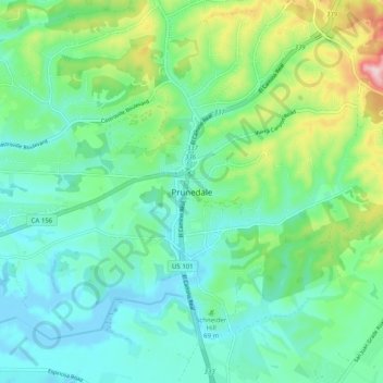
Name: Topografische Karte Prunedale, Höhe, Relief.
Durchschnittliche Höhe: 69 m
Minimale Höhe: -8 m
Maximale Höhe: 275 m
Prunedale is a census-designated place in Monterey County, California. Prunedale is located 8 miles (13 km) north of Salinas, at an elevation of 92 feet (28 m). The population was 17,560 residents at the time of the 2010 census, up from 16,432 at the 2000 census. Plum trees were grown in Prunedale in the early days of its founding but the trees died soon after due to poor irrigation and fertilizer.
Andere topografische Karten
Klicken Sie auf eine Karte, um ihre Topografie, ihre Höhe und ihr Relief anzuzeigen.
Prunedale
United States > California > Monterey County > Prunedale
Prunedale, Monterey County, California, United States
Durchschnittliche Höhe: 104 m