
Topografische Karte Hillsboro
Interaktive Karte
Klicken Sie auf die Karte, um die Höhe anzuzeigen.
Über diese Karte
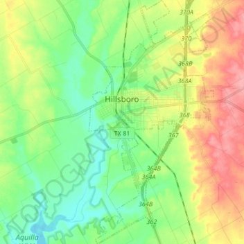
Name: Topografische Karte Hillsboro, Höhe, Relief.
Ort: Hillsboro, Hill County, Texas, 76645, United States (31.94316 -97.14862 32.05685 -97.08000)
Durchschnittliche Höhe: 196 m
Minimale Höhe: 161 m
Maximale Höhe: 251 m
Andere topografische Karten
Klicken Sie auf eine Karte, um ihre Topografie, ihre Höhe und ihr Relief anzuzeigen.
Blum
United States > Texas > Hill County
Blum, Hill County, Texas, United States
Durchschnittliche Höhe: 190 m
Brandon
United States > Texas > Hill County
Brandon, Hill County, Texas, 76628, United States
Durchschnittliche Höhe: 188 m
Penelope
United States > Texas > Hill County > Penelope
Penelope, Hill County, Texas, 76676, United States
Durchschnittliche Höhe: 170 m