
Topografische Karte Stuyvesant Falls
Interaktive Karte
Klicken Sie auf die Karte, um die Höhe anzuzeigen.
Über diese Karte
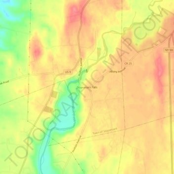
Name: Topografische Karte Stuyvesant Falls, Höhe, Relief.
Durchschnittliche Höhe: 58 m
Minimale Höhe: 11 m
Maximale Höhe: 84 m
Andere topografische Karten
Klicken Sie auf eine Karte, um ihre Topografie, ihre Höhe und ihr Relief anzuzeigen.
Nutten Hook State Tidal Wetland
United States > New York > Columbia County > Town of Stuyvesant
Nutten Hook State Tidal Wetland, Town of Stuyvesant, Columbia County, New York, United States
Durchschnittliche Höhe: 32 m
Newton Hook
United States > New York > Columbia County > Town of Stuyvesant
Newton Hook, Town of Stuyvesant, Columbia County, New York, 12173, United States
Durchschnittliche Höhe: 26 m
Poolsburg
United States > New York > Columbia County > Town of Stuyvesant
Poolsburg, Town of Stuyvesant, Columbia County, New York, 12124, United States
Durchschnittliche Höhe: 39 m