
Topografische Karte Monterey
Interaktive Karte
Klicken Sie auf die Karte, um die Höhe anzuzeigen.
Über diese Karte
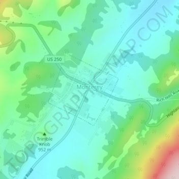
Name: Topografische Karte Monterey, Höhe, Relief.
Ort: Monterey, Highland County, Virginia, United States (38.40608 -79.58749 38.41708 -79.57387)
Durchschnittliche Höhe: 921 m
Minimale Höhe: 835 m
Maximale Höhe: 1.196 m
Andere topografische Karten
Klicken Sie auf eine Karte, um ihre Topografie, ihre Höhe und ihr Relief anzuzeigen.
Bolar
United States > Virginia > Highland County
Bolar, Highland County, Virginia, United States
Durchschnittliche Höhe: 798 m
McDowell
United States > Virginia > Highland County
McDowell, Highland County, Virginia, 24458, United States
Durchschnittliche Höhe: 716 m
Trimble
United States > Virginia > Highland County > Trimble
Trimble, Highland County, Virginia, United States
Durchschnittliche Höhe: 893 m