
Topografische Karte Mount Kerinci
Interaktive Karte
Klicken Sie auf die Karte, um die Höhe anzuzeigen.
Über diese Karte
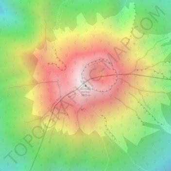
Name: Topografische Karte Mount Kerinci, Höhe, Relief.
Ort: Mount Kerinci, Kerinci, Jambi, Sumatra, Indonesia (-1.69723 101.26460 -1.69713 101.26470)
Durchschnittliche Höhe: 3.229 m
Minimale Höhe: 2.658 m
Maximale Höhe: 3.773 m
Mount Kerinci (also spelled Kerintji, among several other ways, and referred to as Gunung Kerinci, Gadang, Berapi Kurinci, Kerinchi, Korinci/Korintji, or Peak of Indrapura/Indrapoera) is an active stratovolcano and the highest mountain in Sumatra, Indonesia. At 12,484 ft (3,805 m) above sea level, it provides Sumatra with the fifth-highest maximum elevation of any island in the world. It is surrounded by the lush forest of Kerinci Seblat National Park, home to several endangered species including the Sumatran tiger. Mount Kerinci is ranked 32nd by topographic isolation.
Andere topografische Karten
Klicken Sie auf eine Karte, um ihre Topografie, ihre Höhe und ihr Relief anzuzeigen.