
Topografische Karte Carriage Hills
Interaktive Karte
Klicken Sie auf die Karte, um die Höhe anzuzeigen.
Über diese Karte
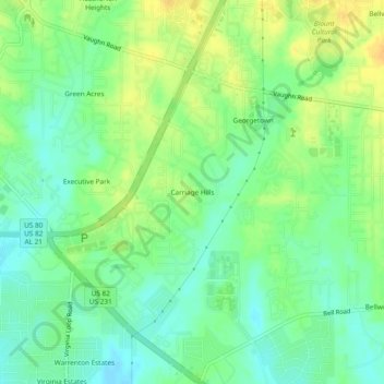
Name: Topografische Karte Carriage Hills, Höhe, Relief.
Durchschnittliche Höhe: 75 m
Minimale Höhe: 62 m
Maximale Höhe: 89 m
Andere topografische Karten
Klicken Sie auf eine Karte, um ihre Topografie, ihre Höhe und ihr Relief anzuzeigen.
Mountain View Estates
United States > Alabama > Montgomery County > Montgomery
Mountain View Estates, Montgomery, Montgomery County, Alabama, 36109, United States
Durchschnittliche Höhe: 80 m
Johnstown East
United States > Alabama > Montgomery County > Montgomery
Johnstown East, Montgomery, Montgomery County, Alabama, 36109, United States
Durchschnittliche Höhe: 73 m
College Grove
United States > Alabama > Montgomery County > Montgomery
College Grove, Montgomery, Montgomery County, Alabama, 36109, United States
Durchschnittliche Höhe: 76 m
Southlawn
United States > Alabama > Montgomery County > Montgomery
Southlawn, Montgomery, Montgomery County, Alabama, 36105, United States
Durchschnittliche Höhe: 57 m
Bellwood Plantation
United States > Alabama > Montgomery County > Montgomery > Bellwood Plantation
Bellwood Plantation, Montgomery, Montgomery County, Alabama, 36123, United States
Durchschnittliche Höhe: 81 m
Mayfair
United States > Alabama > Montgomery County > Montgomery > Mayfair
Mayfair, Montgomery, Montgomery County, Alabama, 36109, United States
Durchschnittliche Höhe: 84 m
Regency Forest
United States > Alabama > Montgomery County > Montgomery > Regency Forest
Regency Forest, Montgomery, Montgomery County, Alabama, 36116, United States
Durchschnittliche Höhe: 67 m
Sunshine Village
United States > Alabama > Montgomery County > Montgomery > Sunshine Village
Sunshine Village, Montgomery, Montgomery County, Alabama, 36119, United States
Durchschnittliche Höhe: 65 m