
Topografische Karte Kampung Melangkap Tiong
Interaktive Karte
Klicken Sie auf die Karte, um die Höhe anzuzeigen.
Über diese Karte
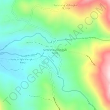
Name: Topografische Karte Kampung Melangkap Tiong, Höhe, Relief.
Durchschnittliche Höhe: 311 m
Minimale Höhe: 198 m
Maximale Höhe: 506 m
Andere topografische Karten
Klicken Sie auf eine Karte, um ihre Topografie, ihre Höhe und ihr Relief anzuzeigen.
Kampung Taginambur
Malaysia > Sabah > Kota Belud
Kampung Taginambur, Kota Belud, West Coast Division, Sabah, 89159, Malaysia
Durchschnittliche Höhe: 142 m
Kampung Tengkurus
Malaysia > Sabah > Kota Belud
Kampung Tengkurus, Kota Belud, West Coast Division, Sabah, Malaysia
Durchschnittliche Höhe: 99 m
Kampung Tambulion
Malaysia > Sabah > Kota Belud
Kampung Tambulion, Kota Belud, West Coast Division, Sabah, 89158, Malaysia
Durchschnittliche Höhe: 30 m
Kota Belud
Malaysia > Sabah > Kota Belud
Kota Belud, West Coast Division, Sabah, 89158, Malaysia
Durchschnittliche Höhe: 41 m
Kampung Kebayau
Malaysia > Sabah > Kota Belud
Kampung Kebayau, Kota Belud, West Coast Division, Sabah, Malaysia
Durchschnittliche Höhe: 277 m
Pekan Nabalu
Malaysia > Sabah > Kota Belud
Pekan Nabalu, Kota Belud, West Coast Division, Sabah, Malaysia
Durchschnittliche Höhe: 761 m