
Topografische Karte Penida Island
Interaktive Karte
Klicken Sie auf die Karte, um die Höhe anzuzeigen.
Über diese Karte
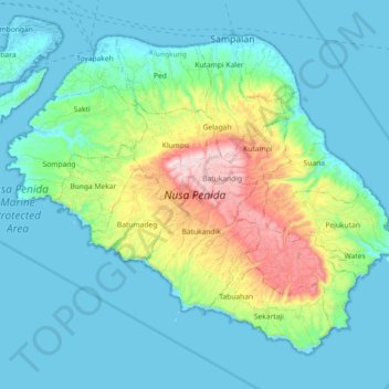
Name: Topografische Karte Penida Island, Höhe, Relief.
Durchschnittliche Höhe: 104 m
Minimale Höhe: -4 m
Maximale Höhe: 517 m
Nusa Penida (Balinese: ᬦᬸᬲᬧᭂᬦᬶᬤ), romanized: nusapĕnida, lit. 'Penida Island') is an island located near the southeastern Indonesian island of Bali and a district of Klungkung Regency that includes the neighbouring small island of Nusa Lembongan and twelve even smaller islands. The Badung Strait separates the island and Bali. The interior of Nusa Penida is hilly with a maximum altitude of 524 metres. It is drier than the nearby island of Bali. It is one of the major tourist attractions among the three Nusa islands.
Andere topografische Karten
Klicken Sie auf eine Karte, um ihre Topografie, ihre Höhe und ihr Relief anzuzeigen.
Bireuen
Indonesia > Bali > Klungkung Regency > Batukandik
Bireuen, Batukandik, Nusa Penida Subdistrict, Klungkung Regency, Bali, Lesser Sunda Islands, Indonesia
Durchschnittliche Höhe: 82 m