
Topografische Karte Mont-Albert
Interaktive Karte
Klicken Sie auf die Karte, um die Höhe anzuzeigen.
Über diese Karte
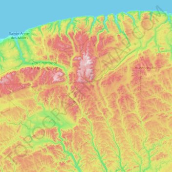
Name: Topografische Karte Mont-Albert, Höhe, Relief.
Durchschnittliche Höhe: 427 m
Minimale Höhe: -2 m
Maximale Höhe: 1.260 m
The ghost town of Saint-Octave-de-l'Avenir is about 18 kilometres (11 mi) south-southeast of Cap-Chat, at an altitude of 380 metres (1,250 ft). It was formed in 1932 as part of the Vautrin Settlement Plan to encourage colonization of Gaspésie's interior and intended to bring relief during the Great Depression of the 1930s. The settlement was named after founding priest Louis-Octave Caron (1879–1942) and a hopeful outlook of the future (avenir is French for "future"). It grew to 1200 residents in 1937 but then declined until it was abandoned in 1971. Only summer camps remain.
Andere topografische Karten
Klicken Sie auf eine Karte, um ihre Topografie, ihre Höhe und ihr Relief anzuzeigen.
Mont-Saint-Pierre
Canada > Quebec > La Haute-Gaspésie
Mont-Saint-Pierre, La Haute-Gaspésie, Gaspésie–Îles-de-la-Madeleine, Quebec, Canada
Durchschnittliche Höhe: 334 m
Gaspésie
Canada > Quebec > La Haute-Gaspésie > Mont-Albert
Gaspésie, Mont-Albert, La Haute-Gaspésie, Gaspésie–Îles-de-la-Madeleine, Quebec, Canada
Durchschnittliche Höhe: 459 m
Sainte-Anne-des-Monts
Canada > Quebec > La Haute-Gaspésie
Sainte-Anne-des-Monts, La Haute-Gaspésie, Gaspésie–Îles-de-la-Madeleine, Quebec, Canada
Durchschnittliche Höhe: 174 m