
Topografische Karte Isla de Mona
Interaktive Karte
Klicken Sie auf die Karte, um die Höhe anzuzeigen.
Über diese Karte
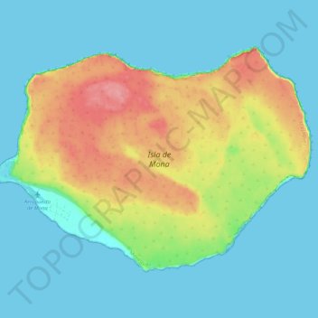
Name: Topografische Karte Isla de Mona, Höhe, Relief.
Ort: Isla de Mona, Mayagüez, Puerto Rico, United States (18.05297 -67.94586 18.12185 -67.84365)
Durchschnittliche Höhe: 26 m
Minimale Höhe: -1 m
Maximale Höhe: 88 m
Mona is a mainly flat plateau surrounded by sea cliffs. It is composed of dolomite and limestone with many caves found throughout. With an arid climate and untouched by human development, many endemic species inhabit the island, such as the Mona ground iguana (Cyclura cornuta stejnegeri). Its topography, ecology, and modern history are similar to that of Navassa Island, a small limestone island located in the Jamaica Channel, between Jamaica and Haiti.
Andere topografische Karten
Klicken Sie auf eine Karte, um ihre Topografie, ihre Höhe und ihr Relief anzuzeigen.
East Ridge
United States > Puerto Rico > Mayagüez
East Ridge, Sabanetas, Mayagüez, Puerto Rico, United States
Durchschnittliche Höhe: 9 m
Juan Alonso
United States > Puerto Rico > Mayagüez
Juan Alonso, Mayagüez, Puerto Rico, United States
Durchschnittliche Höhe: 174 m
Guanajibo
United States > Puerto Rico > Mayagüez
Guanajibo, Mayagüez, Puerto Rico, United States
Durchschnittliche Höhe: 8 m
Naranjales
United States > Puerto Rico > Mayagüez
Naranjales, Mayagüez, Puerto Rico, United States
Durchschnittliche Höhe: 311 m