
Spenden
Rüsten Sie sich für Ihr nächstes Abenteuer:
Als Amazon-Partner verdient diese Website an qualifizierten Käufen, ohne dass Ihnen zusätzliche Kosten entstehen.
Topografische Karte Venthône
Klicken Sie auf die Karte, um die Höhe anzuzeigen.
Spenden
Rüsten Sie sich für Ihr nächstes Abenteuer:
Als Amazon-Partner verdient diese Website an qualifizierten Käufen, ohne dass Ihnen zusätzliche Kosten entstehen.
Über diese Karte
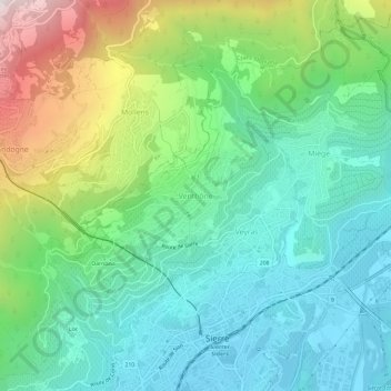
Name: Topografische Karte Venthône, Höhe, Relief.
Ort: Venthône, Noble-Contrée, Sierre, Wallis, 3973, Switzerland (46.28682 7.50910 46.32682 7.54910)
Durchschnittliche Höhe: 855 m
Minimale Höhe: 522 m
Maximale Höhe: 1.669 m
Spenden
Rüsten Sie sich für Ihr nächstes Abenteuer:
Als Amazon-Partner verdient diese Website an qualifizierten Käufen, ohne dass Ihnen zusätzliche Kosten entstehen.
Andere topografische Karten
Klicken Sie auf eine Karte, um ihre Topografie, ihre Höhe und ihr Relief anzuzeigen.
Crans-Montana
Switzerland > Wallis > Sierre
The resort is located in the heart of the Swiss Alps in the French-speaking part of the canton of Valais. It is located on a plateau above Sierre at an elevation of about 1,500 m (4,920 ft) above sea level, allowing good view over the Valais Alps and Weisshorn in particular. The resort is a fusion of the two…
Durchschnittliche Höhe: 1.660 m
Mollens (VS)
Switzerland > Wallis > Sierre > Crans-Montana
The former municipality is located in the Sierre district, on the right bank of the Rhone river. The municipality stretches from an elevation of 900 to 3,177 m (2,953 to 10,423 ft). It consists of the villages of Mollens and Cordona, the scattered settlements of Conzor, Laques and Saint-Maurice-de-Laques as…
Durchschnittliche Höhe: 1.996 m
Randogne
Switzerland > Wallis > Sierre > Crans-Montana
The former municipality is located in the Sierre district, on the northern slope of the Rhone valley. The municipality goes from the Rhone valley at an elevation of 540 m (1,770 ft) to Mont Bonvin at 2,995 m (9,826 ft). It consists of the village of Randogne (which was rebuilt in stone after the destructive…
Durchschnittliche Höhe: 1.614 m
Spenden
Rüsten Sie sich für Ihr nächstes Abenteuer:
Als Amazon-Partner verdient diese Website an qualifizierten Käufen, ohne dass Ihnen zusätzliche Kosten entstehen.
Crans-Montana
Switzerland > Wallis > Sierre
The resort is located in the heart of the Swiss Alps in the French-speaking part of the canton of Valais. It is located on a plateau above Sierre at an elevation of about 1,500 m (4,920 ft) above sea level, allowing a panoramic view over the Valais Alps and Weisshorn in particular. The resort is a fusion of…
Durchschnittliche Höhe: 1.660 m
Sierre
Switzerland > Wallis > Sierre
The hilly topography of the valley floor derives from a very large postglacial rock avalanche, which collapsed from a fractured scar high to the north.
Durchschnittliche Höhe: 1.143 m
Spenden
Rüsten Sie sich für Ihr nächstes Abenteuer:
Als Amazon-Partner verdient diese Website an qualifizierten Käufen, ohne dass Ihnen zusätzliche Kosten entstehen.
Montana
Switzerland > Wallis > Sierre > Crans-Montana
The former municipality is located in the Sierre district, above the right bank of the Rhone. It consists of the villages of Montana and Corin, part of the Champzabé, the hamlet of Diogne as well as the resort of Montana-Vermala (located at an elevation of 1,500 m (4,900 ft) and shared between Montana and…
Durchschnittliche Höhe: 1.231 m