
Topografische Karte Ricketts Glen State Park
Interaktive Karte
Klicken Sie auf die Karte, um die Höhe anzuzeigen.
Über diese Karte
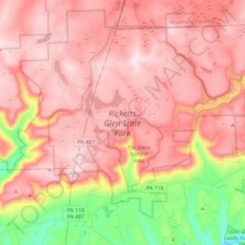
Name: Topografische Karte Ricketts Glen State Park, Höhe, Relief.
Durchschnittliche Höhe: 588 m
Minimale Höhe: 282 m
Maximale Höhe: 751 m
The state's original plans for the new park included building an inn, an 18-hole golf course and country club, and a winter sports complex for skiing, ice boating, and tobogganing, as well as a beach with bathing facilities, cabins, and a tent camping area. Only the last three were actually built, all south of Lake Jean; the Hayfield area north of Lake Jean was to have had the facilities for golf and tennis, and the inn and winter sports complex were to have been atop Cherry Ridge, at an elevation of 2,461 feet (750 m).
Andere topografische Karten
Klicken Sie auf eine Karte, um ihre Topografie, ihre Höhe und ihr Relief anzuzeigen.
Lake Leigh Dam (defunct)
United States > Pennsylvania > Luzerne County > Fairmount Township
Lake Leigh Dam (defunct), Fairmount Township, Luzerne County, Pennsylvania, United States
Durchschnittliche Höhe: 672 m
Red Rock
United States > Pennsylvania > Luzerne County > Fairmount Township
Red Rock, Fairmount Township, Luzerne County, Pennsylvania, United States
Durchschnittliche Höhe: 438 m