
Topografische Karte Kohīma
Interaktive Karte
Klicken Sie auf die Karte, um die Höhe anzuzeigen.
Über diese Karte
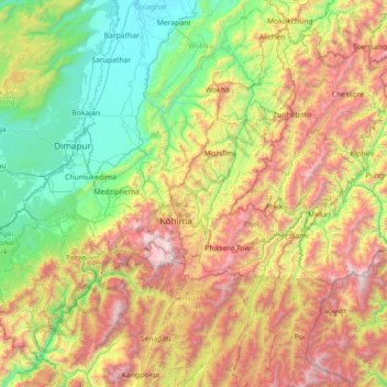
Name: Topografische Karte Kohīma, Höhe, Relief.
Ort: Kohīma, Kohima, Nagaland, 797003, India (25.05000 93.46667 26.45000 94.86667)
Durchschnittliche Höhe: 1.001 m
Minimale Höhe: 93 m
Maximale Höhe: 2.997 m
Andere topografische Karten
Klicken Sie auf eine Karte, um ihre Topografie, ihre Höhe und ihr Relief anzuzeigen.
Chiephobozou
India > Nagaland > Chiephobozou
Chiephobozou, Kohima District, Nagaland, 797105, India
Durchschnittliche Höhe: 1.189 m
Kanubari
India > Nagaland > Mon District
Kanubari, Hunta, Mon District, Nagaland, India
Durchschnittliche Höhe: 154 m
Sechu Zubza
India > Nagaland > Sechu-Zubza > Sechu Zubza
Sechu Zubza, Sechu-Zubza, Kohima, Nagaland, 797002, India
Durchschnittliche Höhe: 1.004 m
Mokokchung
India > Nagaland > ONGPANGKONG (N)
Mokokchung, ONGPANGKONG (N), Mokokchung, Nagaland, 798601, India
Durchschnittliche Höhe: 1.027 m
Kohima
India > Nagaland > Kohima Sadar
Kohima, Kohima Sadar, Kohima, Nagaland, 797001, India
Durchschnittliche Höhe: 1.425 m
Dimapur
India > Nagaland > Dimapur Sadar
Dimapur, Dimapur Sadar, Dimapur, Nagaland, 797112, India
Durchschnittliche Höhe: 204 m
Kigwema Town
India > Nagaland > Jakhama > Kigwema Town
Kigwema Town, Jakhama, Kohima, Nagaland, 797005, India
Durchschnittliche Höhe: 1.688 m
Kiphire
India > Nagaland > Kiphire Sadar
Kiphire, Kiphire Sadar, Kiphire, Nagaland, 798611, India
Durchschnittliche Höhe: 990 m
Doyang HEP Dam
Doyang HEP Dam, Englan, Wokha, Nagaland, India
Durchschnittliche Höhe: 365 m