
Spenden
Rüsten Sie sich für Ihr nächstes Abenteuer:
Als Amazon-Partner verdient diese Website an qualifizierten Käufen, ohne dass Ihnen zusätzliche Kosten entstehen.
Topografische Karte Cervera
Klicken Sie auf die Karte, um die Höhe anzuzeigen.
Spenden
Rüsten Sie sich für Ihr nächstes Abenteuer:
Als Amazon-Partner verdient diese Website an qualifizierten Käufen, ohne dass Ihnen zusätzliche Kosten entstehen.
Cervera
El relieve del término es bastante representativo del paisaje de la comarca. Predominan los valles anchos y generalmente poco profundas, y enmarcadas por largas crestas prácticamente horizontales. El río Ondara es el curso fluvial más destacado del territorio, que lo cruza de sureste a oeste pasando por el sur de la localidad. La altitud oscila entre los 624 metros al este y los 450 metros a orillas del río Ondara. La ciudad se alza a 548 metros sobre el nivel del mar.
Spenden
Rüsten Sie sich für Ihr nächstes Abenteuer:
Als Amazon-Partner verdient diese Website an qualifizierten Käufen, ohne dass Ihnen zusätzliche Kosten entstehen.
Über diese Karte
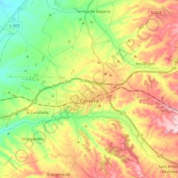
Name: Topografische Karte Cervera, Höhe, Relief.
Ort: Cervera, Segarra, Lérida, Cataluña, España (41.62306 1.22897 41.73783 1.33704)
Durchschnittliche Höhe: 519 m
Minimale Höhe: 387 m
Maximale Höhe: 680 m
Spenden
Rüsten Sie sich für Ihr nächstes Abenteuer:
Als Amazon-Partner verdient diese Website an qualifizierten Käufen, ohne dass Ihnen zusätzliche Kosten entstehen.
Andere topografische Karten
Klicken Sie auf eine Karte, um ihre Topografie, ihre Höhe und ihr Relief anzuzeigen.
Spenden
Rüsten Sie sich für Ihr nächstes Abenteuer:
Als Amazon-Partner verdient diese Website an qualifizierten Käufen, ohne dass Ihnen zusätzliche Kosten entstehen.
Pomar
España > Cataluña > Segarra > Ribera d'Ondara > Sant Antolí i Vilanova
Durchschnittliche Höhe: 604 m
Spenden
Rüsten Sie sich für Ihr nächstes Abenteuer:
Als Amazon-Partner verdient diese Website an qualifizierten Käufen, ohne dass Ihnen zusätzliche Kosten entstehen.