
Topografische Karte Guadalupe
Interaktive Karte
Klicken Sie auf die Karte, um die Höhe anzuzeigen.
Über diese Karte
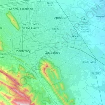
Name: Topografische Karte Guadalupe, Höhe, Relief.
Ort: Guadalupe, Nuevo León, 67180, México (25.51511 -100.37518 25.83511 -100.05518)
Durchschnittliche Höhe: 594 m
Minimale Höhe: 324 m
Maximale Höhe: 2.477 m
Andere topografische Karten
Klicken Sie auf eine Karte, um ihre Topografie, ihre Höhe und ihr Relief anzuzeigen.
Parque Cristo de la Montaña
México > Nuevo León > Guadalupe > Guadalupe
Parque Cristo de la Montaña, Contry La Silla, Guadalupe, Nuevo León, México
Durchschnittliche Höhe: 634 m
Río Santa Catarina
México > Nuevo León > Guadalupe > Monterrey
Río Santa Catarina, Monterrey, Guadalupe, Nuevo León, 64660, México
Durchschnittliche Höhe: 724 m