
Topografische Karte Gresham
Interaktive Karte
Klicken Sie auf die Karte, um die Höhe anzuzeigen.
Über diese Karte
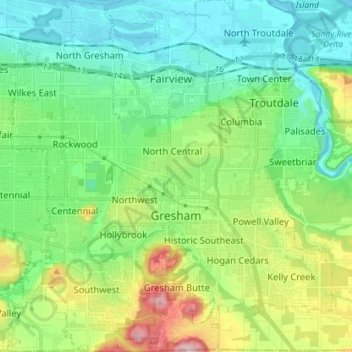
Name: Topografische Karte Gresham, Höhe, Relief.
Ort: Gresham, Multnomah County, Oregon, United States (45.46094 -122.49807 45.56088 -122.36758)
Durchschnittliche Höhe: 90 m
Minimale Höhe: -2 m
Maximale Höhe: 322 m
Though much of Gresham is relatively flat, it is characterized by a hill on its eastern border. Northeast Gresham is also hilly, particularly where the city meets Troutdale toward the Columbia River. Its elevation is 325 feet (99 m). Johnson Creek, which begins at the foothills of the Cascade Mountains, runs westward through Gresham, with 23 percent of the creek's watershed running through the city.
Andere topografische Karten
Klicken Sie auf eine Karte, um ihre Topografie, ihre Höhe und ihr Relief anzuzeigen.
Portland
United States > Oregon > Multnomah County
Portland, Multnomah County, Oregon, United States
Durchschnittliche Höhe: 77 m
Corbett
United States > Oregon > Multnomah County
Corbett, Multnomah County, Oregon, 97019, United States
Durchschnittliche Höhe: 127 m
Sauvie Island
United States > Oregon > Multnomah County
Sauvie Island, Multnomah County, Oregon, United States
Durchschnittliche Höhe: 157 m
Troutdale
United States > Oregon > Multnomah County
Troutdale, Multnomah County, Oregon, 97060, United States
Durchschnittliche Höhe: 54 m
Pearl District
United States > Oregon > Multnomah County > Portland
Pearl District, Portland, Multnomah County, Oregon, United States
Durchschnittliche Höhe: 25 m
East Columbia
United States > Oregon > Multnomah County > Portland
East Columbia, Portland, Multnomah County, Oregon, United States
Durchschnittliche Höhe: 9 m