
Topografische Karte Valdesaz
Interaktive Karte
Klicken Sie auf die Karte, um die Höhe anzuzeigen.
Über diese Karte
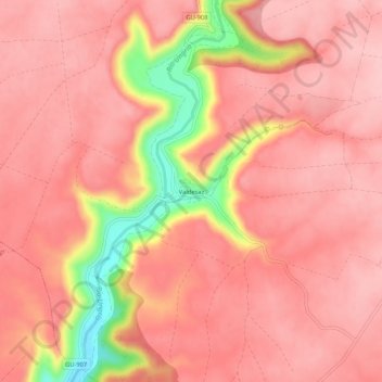
Name: Topografische Karte Valdesaz, Höhe, Relief.
Ort: Valdesaz, Brihuega, Guadalajara, Castilla-La Mancha, España (40.71045 -2.96709 40.75045 -2.92709)
Durchschnittliche Höhe: 971 m
Minimale Höhe: 854 m
Maximale Höhe: 1.007 m
Andere topografische Karten
Klicken Sie auf eine Karte, um ihre Topografie, ihre Höhe und ihr Relief anzuzeigen.
Malacuera
España > Castilla-La Mancha > Brihuega
Malacuera, Brihuega, Guadalajara, Castilla-La Mancha, 19214, España
Durchschnittliche Höhe: 977 m
Olmeda del Extremo
España > Castilla-La Mancha > Brihuega
Olmeda del Extremo, Brihuega, Guadalajara, Castilla-La Mancha, España
Durchschnittliche Höhe: 995 m
Tomellosa
España > Castilla-La Mancha > Brihuega
Tomellosa, Brihuega, Guadalajara, Castilla-La Mancha, 19411, España
Durchschnittliche Höhe: 881 m