
Topografische Karte Olympic National Park
Interaktive Karte
Klicken Sie auf die Karte, um die Höhe anzuzeigen.
Über diese Karte
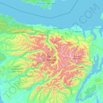
Name: Topografische Karte Olympic National Park, Höhe, Relief.
Durchschnittliche Höhe: 412 m
Minimale Höhe: -3 m
Maximale Höhe: 2.367 m
Views of the Olympic National Park can be seen from the Hurricane Ridge viewpoint. The road leading west from the Hurricane Ridge visitor center has several picnic areas and trailheads. A paved trail called the Hurricane Hill trail is about 1.6 miles (2.6 km) long each way, with an elevation gain of about 700 feet (210 m). It is not uncommon to find snow on the trails even as late as July. Several other dirt trails of varying distances and difficulty levels branch off of the Hurricane hill trail. The picnic areas are open only in the summer and have restrooms, water, and paved access to picnic tables.
Andere topografische Karten
Klicken Sie auf eine Karte, um ihre Topografie, ihre Höhe und ihr Relief anzuzeigen.
Port Townsend
United States > Washington > Jefferson County
Port Townsend, Jefferson County, Washington, United States
Durchschnittliche Höhe: 19 m
Quimper Peninsula
United States > Washington > Jefferson County
Quimper Peninsula, Jefferson County, Washington, 98368, United States
Durchschnittliche Höhe: 69 m
Queets
United States > Washington > Jefferson County
Queets, Jefferson County, Washington, United States
Durchschnittliche Höhe: 36 m
Marrowstone
United States > Washington > Jefferson County > Marrowstone
Marrowstone, Jefferson County, Washington, 98358, United States
Durchschnittliche Höhe: 11 m
Admiralty Inlet
United States > Washington > Jefferson County > Port Townsend
Admiralty Inlet, Port Townsend, Jefferson County, Washington, United States
Durchschnittliche Höhe: 34 m
Chimacum
United States > Washington > Jefferson County
Chimacum, Jefferson County, Washington, 98339, United States
Durchschnittliche Höhe: 59 m
Upper Hoh
United States > Washington > Jefferson County
Upper Hoh, Jefferson County, Washington, United States
Durchschnittliche Höhe: 161 m
Port Ludlow
United States > Washington > Jefferson County > Port Ludlow
Port Ludlow, Jefferson County, Washington, 98365, United States
Durchschnittliche Höhe: 64 m
Port Hadlock
United States > Washington > Jefferson County
Port Hadlock, Jefferson County, Washington, 98339, United States
Durchschnittliche Höhe: 31 m
Lackawanna Beach
United States > Washington > Jefferson County
Lackawanna Beach, Jefferson County, Washington, 98320, United States
Durchschnittliche Höhe: 18 m
Brinnon
United States > Washington > Jefferson County
Brinnon, Jefferson County, Washington, 98320, United States
Durchschnittliche Höhe: 204 m
Port Townsend
United States > Washington > Jefferson County > Port Townsend
Port Townsend, Jefferson County, Washington, United States
Durchschnittliche Höhe: 31 m
Port Townsend
United States > Washington > Jefferson County > Port Townsend > Port Townsend
Port Townsend, Jefferson County, Washington, United States
Durchschnittliche Höhe: 18 m
Mount Townsend
United States > Washington > Jefferson County
Mount Townsend, Jefferson County, Washington, United States
Durchschnittliche Höhe: 1.518 m
Nordland
United States > Washington > Jefferson County > Nordland
Nordland, Jefferson County, Washington, 98339, United States
Durchschnittliche Höhe: 11 m
Mount Olympus
United States > Washington > Jefferson County
Mount Olympus, Jefferson County, Washington, United States
Durchschnittliche Höhe: 1.934 m
Quilcene
United States > Washington > Jefferson County
Quilcene, Jefferson County, Washington, United States
Durchschnittliche Höhe: 116 m
Tukey
United States > Washington > Jefferson County
Tukey, Jefferson County, Washington, United States
Durchschnittliche Höhe: 34 m