
Topografische Karte Boone Fork
Interaktive Karte
Klicken Sie auf die Karte, um die Höhe anzuzeigen.
Über diese Karte
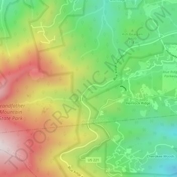
Name: Topografische Karte Boone Fork, Höhe, Relief.
Ort: Boone Fork, Watauga County, North Carolina, 28648, USA (36.11695 -81.80223 36.12513 -81.75878)
Durchschnittliche Höhe: 1.217 m
Minimale Höhe: 879 m
Maximale Höhe: 1.662 m
Andere topografische Karten
Klicken Sie auf eine Karte, um ihre Topografie, ihre Höhe und ihr Relief anzuzeigen.
Roanoke River
Roanoke River, Bertie County, North Carolina, 27962, USA
Durchschnittliche Höhe: 2 m
Albemarle Sound
Albemarle Sound, Tyrrell County, North Carolina, USA
Durchschnittliche Höhe: 0 m
Pfafftown
USA > North Carolina > Pfafftown
Pfafftown, Forsyth County, North Carolina, 27040, USA
Durchschnittliche Höhe: 257 m
Avon
USA > North Carolina > Avon
Avon, Dare County, North Carolina, 27915, USA
Durchschnittliche Höhe: 1 m
Southern Nantahala Wilderness
Southern Nantahala Wilderness, Appalachian Trail, Macon County, North Carolina, USA
Durchschnittliche Höhe: 957 m
Pineville
USA > North Carolina > Pineville
Pineville, Mecklenburg County, North Carolina, 28134, USA
Durchschnittliche Höhe: 180 m
Emma
USA > North Carolina > Emma
Emma, Buncombe County, North Carolina, 28806, USA
Durchschnittliche Höhe: 650 m
Hamptonville
USA > North Carolina > Hamptonville
Hamptonville, Yadkin County, North Carolina, USA
Durchschnittliche Höhe: 297 m
Jarvisburg
USA > North Carolina > Jarvisburg
Jarvisburg, Currituck County, North Carolina, 27947, USA
Durchschnittliche Höhe: 3 m
Lower Creek
USA > North Carolina > Lenoir
Lower Creek, Lenoir, Caldwell County, North Carolina, 28645, USA
Durchschnittliche Höhe: 359 m
Ocean Pines
USA > North Carolina > Ocean Pines
Ocean Pines, Dare County, North Carolina, 27949-9997, USA
Durchschnittliche Höhe: 1 m
Water Creek
Water Creek, Scotland County, North Carolina, USA
Durchschnittliche Höhe: 60 m
Star
USA > North Carolina > Star
Star, Montgomery County, North Carolina, USA
Durchschnittliche Höhe: 181 m
Pasture Bottom Creek
Pasture Bottom Creek, Iredell County, North Carolina, 28689, USA
Durchschnittliche Höhe: 334 m
Bethania
USA > North Carolina > Bethania
Bethania, Forsyth County, North Carolina, 27010, USA
Durchschnittliche Höhe: 258 m
Newton Park
USA > North Carolina > Newton Park
Newton Park, Wilson County, North Carolina, 27896, USA
Durchschnittliche Höhe: 46 m
Saunders Island
Saunders Island, Onslow County, North Carolina, USA
Durchschnittliche Höhe: 5 m
Downs Mountain
Downs Mountain, Macon County, North Carolina, 28763, USA
Durchschnittliche Höhe: 732 m
Dog Islands
Dog Islands, Carteret County, North Carolina, 28575, USA
Durchschnittliche Höhe: 3 m
Ballast Bay
Ballast Bay, Clarion Loop, Currituck County, North Carolina, 27792, USA
Durchschnittliche Höhe: 0 m
Complex
USA > North Carolina > Complex
Complex, Davidson County, North Carolina, USA
Durchschnittliche Höhe: 216 m
Silver Lake
Silver Lake, Ocracoke, Hyde County, North Carolina, 27960, USA
Durchschnittliche Höhe: 1 m