
Topografische Karte Sułoszowa
Interaktive Karte
Klicken Sie auf die Karte, um die Höhe anzuzeigen.
Über diese Karte
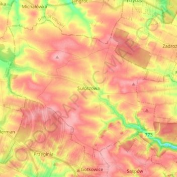
Name: Topografische Karte Sułoszowa, Höhe, Relief.
Durchschnittliche Höhe: 442 m
Minimale Höhe: 367 m
Maximale Höhe: 485 m
Andere topografische Karten
Klicken Sie auf eine Karte, um ihre Topografie, ihre Höhe und ihr Relief anzuzeigen.
Narama
Poland > Lesser Poland Voivodeship > Kraków County
Narama, gmina Iwanowice, Kraków County, Lesser Poland Voivodeship, Poland
Durchschnittliche Höhe: 346 m
Park Krajobrazowy Dolinki Krakowskie
Poland > Lesser Poland Voivodeship > Kraków County > Szklary
Park Krajobrazowy Dolinki Krakowskie, Szklary, gmina Jerzmanowice-Przeginia, Kraków County, Lesser Poland Voivodeship, 32-063, Poland
Durchschnittliche Höhe: 341 m
Podzamcze
Poland > Lesser Poland Voivodeship > Kraków County > Korzkiew > Podzamcze
Podzamcze, Korzkiew, gmina Zielonki, Kraków County, Lesser Poland Voivodeship, Poland
Durchschnittliche Höhe: 321 m
Żbik
Poland > Lesser Poland Voivodeship > Kraków County > Krzeszowice
Żbik, Krzeszowice, gmina Krzeszowice, Kraków County, Lesser Poland Voivodeship, 32-065, Poland
Durchschnittliche Höhe: 317 m
Bielańsko-Tyniecki Park Krajobrazowy
Poland > Lesser Poland Voivodeship > Kraków County > Krakow
Bielańsko-Tyniecki Park Krajobrazowy, Krakow, gmina Liszki, Kraków County, Lesser Poland Voivodeship, Poland
Durchschnittliche Höhe: 239 m
Tenczyński Park Krajobrazowy
Poland > Lesser Poland Voivodeship > Kraków County
Tenczyński Park Krajobrazowy, Kraków County, Lesser Poland Voivodeship, Poland
Durchschnittliche Höhe: 308 m
Leszczynowa
Poland > Lesser Poland Voivodeship > Kraków County > Chrosna
Leszczynowa, Chrosna, gmina Liszki, Kraków County, Lesser Poland Voivodeship, Poland
Durchschnittliche Höhe: 307 m
Kleszczów
Poland > Lesser Poland Voivodeship > Kraków County
Kleszczów, gmina Zabierzów, Kraków County, Lesser Poland Voivodeship, Poland
Durchschnittliche Höhe: 309 m
Szklary
Poland > Lesser Poland Voivodeship > Kraków County
Szklary, gmina Jerzmanowice-Przeginia, Kraków County, Lesser Poland Voivodeship, Poland
Durchschnittliche Höhe: 411 m
Werychów
Poland > Lesser Poland Voivodeship > Kraków County > Balice
Werychów, Balice, gmina Zabierzów, Kraków County, Lesser Poland Voivodeship, 31-083, Poland
Durchschnittliche Höhe: 238 m
Siedlisko
Poland > Lesser Poland Voivodeship > Kraków County > Radziszów
Siedlisko, Radziszów, gmina Skawina, Kraków County, Lesser Poland Voivodeship, 32-052, Poland
Durchschnittliche Höhe: 262 m
Czerna
Poland > Lesser Poland Voivodeship > Kraków County
Czerna, gmina Krzeszowice, Kraków County, Lesser Poland Voivodeship, Poland
Durchschnittliche Höhe: 400 m
Słomniki
Poland > Lesser Poland Voivodeship > Kraków County > Słomniki
Słomniki, gmina Słomniki, Kraków County, Lesser Poland Voivodeship, 32-090, Poland
Durchschnittliche Höhe: 250 m
Rudawa
Poland > Lesser Poland Voivodeship > Kraków County
Rudawa, Kraków County, Lesser Poland Voivodeship, 32-080, Poland
Durchschnittliche Höhe: 262 m
Czułówek
Poland > Lesser Poland Voivodeship > Kraków County > Czułówek > Czułówek
Czułówek, gmina Czernichów, Kraków County, Lesser Poland Voivodeship, 32-061, Poland
Durchschnittliche Höhe: 264 m
Balice
Poland > Lesser Poland Voivodeship > Kraków County > Balice
Balice, gmina Zabierzów, Kraków County, Lesser Poland Voivodeship, 32-083, Poland
Durchschnittliche Höhe: 254 m
Maszyce
Poland > Lesser Poland Voivodeship > Kraków County
Maszyce, gmina Skała, Kraków County, Lesser Poland Voivodeship, Poland
Durchschnittliche Höhe: 366 m
Chorowice
Poland > Lesser Poland Voivodeship > Kraków County
Chorowice, gmina Mogilany, Kraków County, Lesser Poland Voivodeship, Poland
Durchschnittliche Höhe: 314 m
Radwanowice
Poland > Lesser Poland Voivodeship > Kraków County
Radwanowice, gmina Zabierzów, Kraków County, Lesser Poland Voivodeship, Poland
Durchschnittliche Höhe: 329 m