
Topografische Karte Mineral
Interaktive Karte
Klicken Sie auf die Karte, um die Höhe anzuzeigen.
Über diese Karte
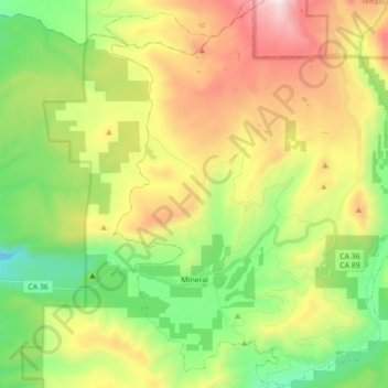
Name: Topografische Karte Mineral, Höhe, Relief.
Ort: Mineral, Tehama County, California, United States (40.30922 -121.64008 40.44337 -121.50154)
Durchschnittliche Höhe: 1.752 m
Minimale Höhe: 1.141 m
Maximale Höhe: 2.686 m
Andere topografische Karten
Klicken Sie auf eine Karte, um ihre Topografie, ihre Höhe und ihr Relief anzuzeigen.
Manton
United States > California > Tehama County
Manton, Tehama County, California, United States
Durchschnittliche Höhe: 722 m
Red Bluff
United States > California > Tehama County
Red Bluff, Tehama County, California, 96080, United States
Durchschnittliche Höhe: 103 m
Manton
United States > California > Tehama County
Manton, Tehama County, California, United States
Durchschnittliche Höhe: 722 m
Paskenta
United States > California > Tehama County
Paskenta, Tehama County, California, 96074, United States
Durchschnittliche Höhe: 268 m
Rancho Tehama Reserve
United States > California > Tehama County
Rancho Tehama Reserve, Tehama County, CAL Fire Northern Region, California, United States
Durchschnittliche Höhe: 237 m
Corning
United States > California > Tehama County
Corning, Tehama County, CAL Fire Northern Region, California, 96021, United States
Durchschnittliche Höhe: 86 m
Paynes Creek
United States > California > Tehama County
Paynes Creek, Tehama County, California, United States
Durchschnittliche Höhe: 143 m
Paynes Creek
United States > California > Tehama County > Dales
Paynes Creek, Dales, Tehama County, CAL Fire Northern Region, California, United States
Durchschnittliche Höhe: 222 m
Los Molinos
United States > California > Tehama County > Los Molinos
Los Molinos, Tehama County, California, 96055, United States
Durchschnittliche Höhe: 76 m