
Topografische Karte Lake Ozark
Interaktive Karte
Klicken Sie auf die Karte, um die Höhe anzuzeigen.
Über diese Karte
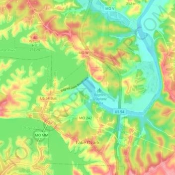
Name: Topografische Karte Lake Ozark, Höhe, Relief.
Ort: Lake Ozark, Miller County, Missouri, United States (38.17074 -92.67241 38.23088 -92.58711)
Durchschnittliche Höhe: 213 m
Minimale Höhe: 167 m
Maximale Höhe: 272 m
Andere topografische Karten
Klicken Sie auf eine Karte, um ihre Topografie, ihre Höhe und ihr Relief anzuzeigen.
Aurora Springs
United States > Missouri > Miller County
Aurora Springs, Miller County, Missouri, 65026, United States
Durchschnittliche Höhe: 274 m
Lakeside
United States > Missouri > Miller County
Lakeside, Miller County, Missouri, United States
Durchschnittliche Höhe: 209 m
Bagnell
United States > Missouri > Miller County
Bagnell, Miller County, Missouri, United States
Durchschnittliche Höhe: 198 m
High Point
United States > Missouri > Miller County
High Point, Miller County, Missouri, United States
Durchschnittliche Höhe: 252 m
Tuscumbia
United States > Missouri > Miller County
Tuscumbia, Miller County, Missouri, United States
Durchschnittliche Höhe: 198 m
Rocky Mount
United States > Missouri > Miller County
Rocky Mount, Miller County, Missouri, United States
Durchschnittliche Höhe: 278 m
Saint Elizabeth
United States > Missouri > Miller County > St. Elizabeth
Saint Elizabeth, St. Elizabeth, Miller County, Missouri, 65075, United States
Durchschnittliche Höhe: 216 m
Eldon
United States > Missouri > Miller County
Eldon, Miller County, Missouri, United States
Durchschnittliche Höhe: 280 m