
Topografische Karte Big White Mountain
Interaktive Karte
Klicken Sie auf die Karte, um die Höhe anzuzeigen.
Über diese Karte
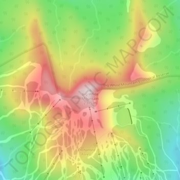
Name: Topografische Karte Big White Mountain, Höhe, Relief.
Durchschnittliche Höhe: 2.060 m
Minimale Höhe: 1.824 m
Maximale Höhe: 2.314 m
Andere topografische Karten
Klicken Sie auf eine Karte, um ihre Topografie, ihre Höhe und ihr Relief anzuzeigen.
Stump Lake
Canada > British Columbia > Regional District of Kootenay Boundary > Area E (Beaverdell/West Boundary)
Stump Lake, Area E (Beaverdell/West Boundary), Regional District of Kootenay Boundary, British Columbia, Canada
Durchschnittliche Höhe: 1.321 m
Idabel Lake
Canada > British Columbia > Regional District of Kootenay Boundary > Area E (Beaverdell/West Boundary)
Idabel Lake, Area E (Beaverdell/West Boundary), Regional District of Kootenay Boundary, British Columbia, Canada
Durchschnittliche Höhe: 1.268 m
Rock Creek
Canada > British Columbia > Regional District of Kootenay Boundary > Area E (Beaverdell/West Boundary)
Rock Creek, Area E (Beaverdell/West Boundary), Regional District of Kootenay Boundary, British Columbia, V0H 1Y0, Canada
Durchschnittliche Höhe: 764 m
Beaverdell
Canada > British Columbia > Regional District of Kootenay Boundary > Area E (Beaverdell/West Boundary)
Beaverdell, Area E (Beaverdell/West Boundary), Regional District of Kootenay Boundary, British Columbia, Canada
Durchschnittliche Höhe: 956 m
Mount Baldy
Canada > British Columbia > Regional District of Kootenay Boundary > Area E (Beaverdell/West Boundary)
Mount Baldy, Area E (Beaverdell/West Boundary), Regional District of Kootenay Boundary, British Columbia, Canada
Durchschnittliche Höhe: 1.813 m