
Topografische Karte Rajkot
Interaktive Karte
Klicken Sie auf die Karte, um die Höhe anzuzeigen.
Über diese Karte
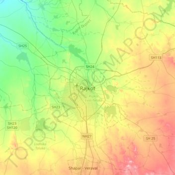
Name: Topografische Karte Rajkot, Höhe, Relief.
Ort: Rajkot, Rajkot Taluka, Rajkot District, Gujarat, 360001, India (22.14533 70.64284 22.46533 70.96284)
Durchschnittliche Höhe: 141 m
Minimale Höhe: 65 m
Maximale Höhe: 257 m
Rajkot is located at 22°18′N 70°47′E / 22.3°N 70.78°E / 22.3; 70.78. It has an average elevation of 128 metres (420 ft). The city is located on the bank of Aji River and Nyari River which remains dry except the monsoon months of July to September. The city is spread in the area of 170.00 km2.