
Topografische Karte Piravom
Interaktive Karte
Klicken Sie auf die Karte, um die Höhe anzuzeigen.
Piravom
The panchayat had been a municipality for a brief period of about two years before it was reverted to a panchayat in 1992 after skepticism that a municipality would attract higher tax rate and complexities of building rules. However, the municipal councils now have the authority to fix the tax rate while building rule provisions are already applicable to special grade Panchayats. The panchayat had passed a unanimous resolution for the elevation. In 2015, Kerala government elevated Piravom panchayat to a municipality along with several other towns in Kerala.
Über diese Karte
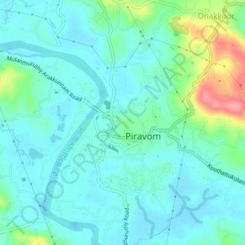
Name: Topografische Karte Piravom, Höhe, Relief.
Ort: Piravom, Muvattupuzha, Ernakulam district, Kerala, 686664, India (9.86216 76.46936 9.88828 76.50349)
Durchschnittliche Höhe: 21 m
Minimale Höhe: -3 m
Maximale Höhe: 97 m
Andere topografische Karten
Klicken Sie auf eine Karte, um ihre Topografie, ihre Höhe und ihr Relief anzuzeigen.