
Topografische Karte Addison
Interaktive Karte
Klicken Sie auf die Karte, um die Höhe anzuzeigen.
Über diese Karte
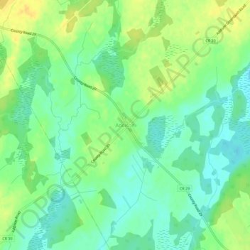
Name: Topografische Karte Addison, Höhe, Relief.
Durchschnittliche Höhe: 119 m
Minimale Höhe: 107 m
Maximale Höhe: 133 m
Andere topografische Karten
Klicken Sie auf eine Karte, um ihre Topografie, ihre Höhe und ihr Relief anzuzeigen.
Harvey Island
Canada > Ontario > Leeds and Grenville Counties > Elizabethtown-Kitley
Harvey Island, Elizabethtown-Kitley, Leeds and Grenville Counties, Eastern Ontario, Ontario, K6V 5T7, Canada
Durchschnittliche Höhe: 111 m
Motts Mills
Canada > Ontario > Leeds and Grenville Counties > Elizabethtown-Kitley
Motts Mills, Elizabethtown-Kitley, Leeds and Grenville Counties, Eastern Ontario, Ontario, K0G 1L0, Canada
Durchschnittliche Höhe: 126 m
Greenbush
Canada > Ontario > Leeds and Grenville Counties > Elizabethtown-Kitley > Greenbush
Greenbush, Elizabethtown-Kitley, Leeds and Grenville Counties, Eastern Ontario, Ontario, K0E 1A0, Canada
Durchschnittliche Höhe: 120 m
Toledo
Canada > Ontario > Leeds and Grenville Counties > Elizabethtown-Kitley
Toledo, Elizabethtown-Kitley, Leeds and Grenville Counties, Eastern Ontario, Ontario, K0E 1Y0, Canada
Durchschnittliche Höhe: 121 m
Lyn
Canada > Ontario > Leeds and Grenville Counties > Elizabethtown-Kitley
Lyn, Elizabethtown-Kitley, Leeds and Grenville Counties, Eastern Ontario, Ontario, K0E 1M0, Canada
Durchschnittliche Höhe: 102 m