
Topografische Karte Broken Arrow
Interaktive Karte
Klicken Sie auf die Karte, um die Höhe anzuzeigen.
Über diese Karte
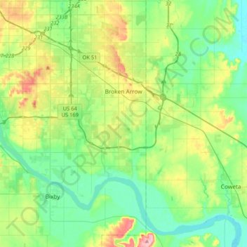
Name: Topografische Karte Broken Arrow, Höhe, Relief.
Ort: Broken Arrow, Tulsa County, Oklahoma, United States (35.91800 -95.86836 36.11914 -95.54636)
Durchschnittliche Höhe: 205 m
Minimale Höhe: 164 m
Maximale Höhe: 303 m
Broken Arrow is located in the northeastern corner of Oklahoma. The city is part of the state's Green Country region known for its green vegetation, hills and lakes. Green Country is the most topographically diverse portion of the state with seven of Oklahoma's 11 eco-regions.
Andere topografische Karten
Klicken Sie auf eine Karte, um ihre Topografie, ihre Höhe und ihr Relief anzuzeigen.
Tulsa
United States > Oklahoma > Tulsa County
Tulsa, Tulsa County, Oklahoma, United States
Durchschnittliche Höhe: 221 m
Owasso
United States > Oklahoma > Tulsa County
Owasso, Tulsa County, Oklahoma, 74055, United States
Durchschnittliche Höhe: 199 m
Bixby
United States > Oklahoma > Tulsa County
Bixby, Tulsa County, Oklahoma, 74008, United States
Durchschnittliche Höhe: 204 m
Wellington South
United States > Oklahoma > Tulsa County > Tulsa
Wellington South, Tulsa, Tulsa County, Oklahoma, United States
Durchschnittliche Höhe: 206 m
Audobon Park
United States > Oklahoma > Tulsa County > Tulsa
Audobon Park, Tulsa, Tulsa County, Oklahoma, United States
Durchschnittliche Höhe: 215 m
Oakhurst
United States > Oklahoma > Tulsa County
Oakhurst, Tulsa County, Oklahoma, United States
Durchschnittliche Höhe: 228 m
Collinsville
United States > Oklahoma > Tulsa County
Collinsville, Tulsa County, Oklahoma, United States
Durchschnittliche Höhe: 197 m
Sand Springs
United States > Oklahoma > Tulsa County
Sand Springs, Tulsa County, Oklahoma, United States
Durchschnittliche Höhe: 238 m
Sperry
United States > Oklahoma > Tulsa County
Sperry, Tulsa County, Oklahoma, 74073, United States
Durchschnittliche Höhe: 191 m
Tulsa
United States > Oklahoma > Tulsa County > Tulsa
Tulsa, Tulsa County, Oklahoma, 74172, United States
Durchschnittliche Höhe: 220 m
Glenpool
United States > Oklahoma > Tulsa County
Glenpool, Tulsa County, Oklahoma, 74033, United States
Durchschnittliche Höhe: 223 m
Case Community Park
United States > Oklahoma > Tulsa County > Sand Springs > Shirk
Case Community Park, Shirk, Sand Springs, Tulsa County, Oklahoma, United States
Durchschnittliche Höhe: 203 m
Sperry
United States > Oklahoma > Tulsa County > Sperry
Sperry, Tulsa County, Oklahoma, United States
Durchschnittliche Höhe: 188 m
Sand Springs
United States > Oklahoma > Tulsa County > Sand Springs > Sand Springs
Sand Springs, Tulsa County, Oklahoma, 74063, United States
Durchschnittliche Höhe: 230 m
Owasso
United States > Oklahoma > Tulsa County > Owasso > Owasso
Owasso, Tulsa County, Oklahoma, 74055, United States
Durchschnittliche Höhe: 193 m
Mingo
United States > Oklahoma > Tulsa County > Tulsa
Mingo, Tulsa, Tulsa County, Oklahoma, 74117, United States
Durchschnittliche Höhe: 185 m
Jenks
United States > Oklahoma > Tulsa County
Jenks, Tulsa County, Oklahoma, 74037, United States
Durchschnittliche Höhe: 205 m
Terrace Park
United States > Oklahoma > Tulsa County > Tulsa
Terrace Park, Southern Plaza, Tulsa, Tulsa County, Oklahoma, United States
Durchschnittliche Höhe: 224 m
Turley
United States > Oklahoma > Tulsa County
Turley, Tulsa County, Oklahoma, 74130, United States
Durchschnittliche Höhe: 200 m