
Topografische Karte Valencia
Interaktive Karte
Klicken Sie auf die Karte, um die Höhe anzuzeigen.
Valencia
Valencia occupies an area of 14,749 hectares (36,450 acres), 35% of which are classified as plains. The town is 65% mountainous, with elevation averaging from 200 to 500 metres (660 to 1,640 ft) above sea level, with the top of Mount Talinis at an elevation of 1,903 metres (6,243 ft) along the municipal southern boundary. The climate in the municipality is relatively cool, especially at higher elevations.
Über diese Karte
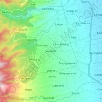
Name: Topografische Karte Valencia, Höhe, Relief.
Ort: Valencia, Negros Oriental, Central Visayas, 6215, Philippines (9.24178 123.20468 9.32178 123.28468)
Durchschnittliche Höhe: 250 m
Minimale Höhe: 24 m
Maximale Höhe: 966 m
Andere topografische Karten
Klicken Sie auf eine Karte, um ihre Topografie, ihre Höhe und ihr Relief anzuzeigen.